Framed Print > Europe > Poland > Maps
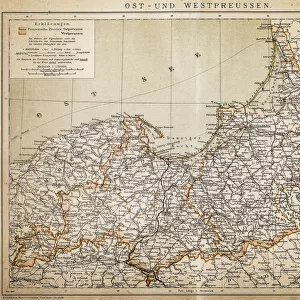
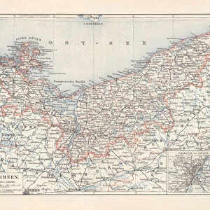
Framed Print : Map of East and West Prussia, Germany, lithograph, published 1897


![]()
Framed Photos from Fine Art Storehouse
Map of East and West Prussia, Germany, lithograph, published 1897
Historical topographic map of East and West Prussia in Germany (now Poland and Russia). Lithograph, published in 1897
Unleash your creativity and transform your space into a visual masterpiece!
ZU_09
Media ID 18292211
12"x10" Modern Frame
Step back in time with our exquisite Framed Print of the historical Map of East and West Prussia, Germany, published in 1897. This intricately detailed lithograph, sourced from the esteemed Fine Art Storehouse (ZU_09), offers a captivating glimpse into the past. The map, which now depicts regions of Poland and Russia, is a must-have for history enthusiasts, geography aficionados, or anyone who appreciates the beauty of vintage cartography. Bring a piece of the past into your home or office with this stunning, preservation-framed print.
10x8 Print in an MDF Wooden Frame with 180 gsm Satin Finish Paper. Glazed using shatter proof thin plexi glass. Frame thickness is 1 inch and depth 0.75 inch. Fluted cardboard backing held with clips. Supplied ready to hang with sawtooth hanger and rubber bumpers. Spot clean with a damp cloth. Packaged foam wrapped in a card.
Contemporary Framed and Mounted Prints - Professionally Made and Ready to Hang
Estimated Image Size (if not cropped) is 25.4cm x 25.4cm (10" x 10")
Estimated Product Size is 30.5cm x 25.4cm (12" x 10")
These are individually made so all sizes are approximate
Artwork printed orientated as per the preview above, with landscape (horizontal) or portrait (vertical) orientation to match the source image.
FEATURES IN THESE COLLECTIONS
> Fine Art Storehouse
> Map
> Historical Maps
> Europe
> Germany
> Related Images
> Europe
> Poland
> Related Images
> Europe
> Russia
> Related Images
> Maps and Charts
> Early Maps
EDITORS COMMENTS
This lithograph, titled "Map of East and West Prussia, Germany" takes us on a journey back in time to the year 1897. A historical topographic map meticulously crafted with intricate details, it offers a glimpse into the past when these lands were known as East and West Prussia in Germany. The print showcases the remarkable craftsmanship of its creator, ZU_09, who expertly captures the essence of this region's geography. Every contour line and river is delicately etched onto the lithograph, allowing us to explore this land that has undergone significant changes over the years. Once an integral part of Germany but now divided between Poland and Russia, East and West Prussia hold great historical significance. This artwork serves as a visual testament to their rich heritage and complex history. As we gaze upon this print, we are transported back in time to an era where borders shifted and cultures intertwined. It reminds us of how our world is constantly evolving while preserving fragments of its past within maps like these. Whether you are a history enthusiast or simply appreciate fine artistry, this lithograph offers both aesthetic pleasure and educational value. It invites us to reflect upon the ever-changing nature of our world while appreciating the beauty found within even seemingly mundane objects such as maps.
MADE IN THE USA
Safe Shipping with 30 Day Money Back Guarantee
FREE PERSONALISATION*
We are proud to offer a range of customisation features including Personalised Captions, Color Filters and Picture Zoom Tools
SECURE PAYMENTS
We happily accept a wide range of payment options so you can pay for the things you need in the way that is most convenient for you
* Options may vary by product and licensing agreement. Zoomed Pictures can be adjusted in the Cart.