Fine Art Print > Europe > Poland > Maps
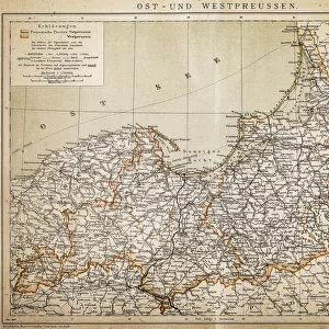
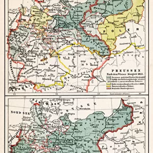
Fine Art Print : Map of East and West Prussia, Germany, lithograph, published 1897


![]()
Fine Art Prints from Fine Art Storehouse
Map of East and West Prussia, Germany, lithograph, published 1897
Historical topographic map of East and West Prussia in Germany (now Poland and Russia). Lithograph, published in 1897
Unleash your creativity and transform your space into a visual masterpiece!
ZU_09
Media ID 18292211
20"x16" (+3" Border) Fine Art Print
Step back in time with our exquisite Fine Art Print of the historical Map of East and West Prussia, published in 1897 by ZU_09. This intricately detailed lithograph offers a captivating glimpse into the past, showcasing the political boundaries of the region during that era. A must-have for history enthusiasts, collectors, and those who appreciate the beauty of antique cartography. Bring a piece of the past into your home or office today with Media Storehouse's Fine Art Prints.
20x16 image printed on 26x22 Fine Art Rag Paper with 3" (76mm) white border. Our Fine Art Prints are printed on 300gsm 100% acid free, PH neutral paper with archival properties. This printing method is used by museums and art collections to exhibit photographs and art reproductions.
Our fine art prints are high-quality prints made using a paper called Photo Rag. This 100% cotton rag fibre paper is known for its exceptional image sharpness, rich colors, and high level of detail, making it a popular choice for professional photographers and artists. Photo rag paper is our clear recommendation for a fine art paper print. If you can afford to spend more on a higher quality paper, then Photo Rag is our clear recommendation for a fine art paper print.
Estimated Image Size (if not cropped) is 50.6cm x 40.6cm (19.9" x 16")
Estimated Product Size is 66cm x 55.9cm (26" x 22")
These are individually made so all sizes are approximate
Artwork printed orientated as per the preview above, with landscape (horizontal) orientation to match the source image.
FEATURES IN THESE COLLECTIONS
> Europe
> Germany
> Related Images
> Europe
> Poland
> Related Images
> Europe
> Russia
> Related Images
> Maps and Charts
> Early Maps
> Fine Art Storehouse
> Map
> Historical Maps
EDITORS COMMENTS
This lithograph, titled "Map of East and West Prussia, Germany" takes us on a journey back in time to the year 1897. A historical topographic map meticulously crafted with intricate details, it offers a glimpse into the past when these lands were known as East and West Prussia in Germany. The print showcases the remarkable craftsmanship of its creator, ZU_09, who expertly captures the essence of this region's geography. Every contour line and river is delicately etched onto the lithograph, allowing us to explore this land that has undergone significant changes over the years. Once an integral part of Germany but now divided between Poland and Russia, East and West Prussia hold great historical significance. This artwork serves as a visual testament to their rich heritage and complex history. As we gaze upon this print, we are transported back in time to an era where borders shifted and cultures intertwined. It reminds us of how our world is constantly evolving while preserving fragments of its past within maps like these. Whether you are a history enthusiast or simply appreciate fine artistry, this lithograph offers both aesthetic pleasure and educational value. It invites us to reflect upon the ever-changing nature of our world while appreciating the beauty found within even seemingly mundane objects such as maps.
MADE IN THE USA
Safe Shipping with 30 Day Money Back Guarantee
FREE PERSONALISATION*
We are proud to offer a range of customisation features including Personalised Captions, Color Filters and Picture Zoom Tools
SECURE PAYMENTS
We happily accept a wide range of payment options so you can pay for the things you need in the way that is most convenient for you
* Options may vary by product and licensing agreement. Zoomed Pictures can be adjusted in the Cart.