Framed Print > Africa > Sudan > Maps
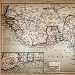
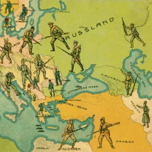
Framed Print : Historical map of Upper-, Lower-Guinea and West-Sudan, lithograph, published 1897


![]()
Framed Photos from Fine Art Storehouse
Historical map of Upper-, Lower-Guinea and West-Sudan, lithograph, published 1897
Historical map of Upper-, Lower-Guinea and West Suadn, West Africa. Lithograph, published in 1897
Unleash your creativity and transform your space into a visual masterpiece!
ZU_09
Media ID 18292323
18"x14" Modern Frame
Step back in time with our exquisite Framed Print of a Historical Map of Upper-, Lower-Guinea and West-Sudan, published in 1897. This intricately detailed lithograph, sourced from the Fine Art Storehouse under the reference ZU_09, offers a fascinating glimpse into the cartography of West Africa during a pivotal period in its history. The antique map, framed in a contemporary style, is an elegant addition to any home or office, perfect for history enthusiasts, collectors, or those who appreciate the beauty of historical art. Bring a piece of the past into your present with this captivating framed print.
16x12 Print in an MDF Wooden Frame with 180 gsm Satin Finish Paper. Glazed using shatter proof thin plexiglass. Frame thickness is 1 inch and depth 0.75 inch. Fluted cardboard backing held with clips. Supplied ready to hang with sawtooth hanger and rubber bumpers. Spot clean with a damp cloth. Packaged foam wrapped in a card.
Contemporary Framed and Mounted Prints - Professionally Made and Ready to Hang
Estimated Image Size (if not cropped) is 40.6cm x 35.6cm (16" x 14")
Estimated Product Size is 45.7cm x 35.6cm (18" x 14")
These are individually made so all sizes are approximate
Artwork printed orientated as per the preview above, with landscape (horizontal) orientation to match the source image.
FEATURES IN THESE COLLECTIONS
> Fine Art Storehouse
> Map
> Historical Maps
> Africa
> Guinea
> Related Images
> Africa
> Related Images
> Africa
> Sudan
> Related Images
> Maps and Charts
> Early Maps
> Maps and Charts
> Related Images
EDITORS COMMENTS
This lithograph, titled "Historical map of Upper-, Lower-Guinea and West-Sudan" takes us on a visual journey through the rich history of West Africa. Published in 1897, this intricate piece offers a glimpse into the region's past, showcasing its diverse geography and cultural heritage. The map is meticulously detailed, with delicate lines tracing the contours of rivers, mountains, and coastlines. It highlights important cities and trading routes that played significant roles in shaping the history of Upper Guinea, Lower Guinea, and West Sudan. As we study this print closely, we can almost feel ourselves transported back to a time when these lands were vibrant hubs of commerce and cultural exchange. The lithograph exudes an air of nostalgia as it captures the essence of a bygone era. Its sepia tones lend an antique charm to the artwork while evoking a sense of reverence for the historical significance it represents. The artist's skillful rendering brings life to each stroke on paper – every line telling stories untold. As we admire this remarkable piece from Fine Art Storehouse by ZU_09, our imagination runs wild with tales from ancient civilizations that once thrived across these lands. This print serves as both an educational tool for historians and a beautiful decorative item for art enthusiasts who appreciate not only aesthetic beauty but also value historical context within their collections.
MADE IN THE USA
Safe Shipping with 30 Day Money Back Guarantee
FREE PERSONALISATION*
We are proud to offer a range of customisation features including Personalised Captions, Color Filters and Picture Zoom Tools
SECURE PAYMENTS
We happily accept a wide range of payment options so you can pay for the things you need in the way that is most convenient for you
* Options may vary by product and licensing agreement. Zoomed Pictures can be adjusted in the Cart.