Home > Africa > Ethiopia (Abyssinia) > Maps
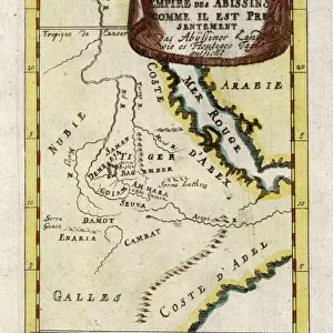
1837, Malte-Brun Map of Ancient Egypt, Nubia, Sudan and Abyssinia, Ethiopia, topography

![]()
Wall Art and Photo Gifts from Liszt Collection
1837, Malte-Brun Map of Ancient Egypt, Nubia, Sudan and Abyssinia, Ethiopia, topography
1837, Malte-Brun Map of Ancient Egypt, Nubia, Sudan and Abyssinia, Ethiopia
Liszt Collection of nineteenth-century engravings and images to browse and enjoy
Media ID 14005063
© Artokoloro Quint Lox Limited
1837 Ethiopia Nubia Antique Map Atlas Chart Geographic Latitude Longitude Mappa Mundi Old Antique Plan Old Antique View Old Map Ols Antique Map Rare Old Maps Topo
FEATURES IN THESE COLLECTIONS
> Africa
> Ethiopia (Abyssinia)
> Maps
> Africa
> Ethiopia
> Related Images
> Maps and Charts
> Early Maps
> Maps and Charts
> World
EDITORS COMMENTS
This print showcases the remarkable 1837 Malte-Brun Map of Ancient Egypt, Nubia, Sudan and Abyssinia, Ethiopia. A true treasure for cartography enthusiasts and history buffs alike, this topographical masterpiece offers a glimpse into the ancient world with its intricate details and meticulous craftsmanship. The map's rich illustration beautifully captures the geographic features of these regions, providing an invaluable resource for travelers and explorers of that era. Its carefully plotted grid lines reveal latitude and longitude coordinates, allowing users to navigate through the vast lands with ease. As a vintage piece of art on aged paper, this historic map exudes an aura of authenticity that transports us back in time. Its decorative elements add to its charm while evoking a sense of wonder about the journeys undertaken by early adventurers. With its historical significance and rare nature, this antique map is not only a visual delight but also serves as a valuable educational tool. It sheds light on ancient civilizations' understanding of their surroundings while offering insights into how our knowledge has evolved over time. Whether displayed in homes or offices, this stunning print from the Liszt Collection sparks curiosity about our planet's past while celebrating human ingenuity in mapping uncharted territories.
MADE IN THE USA
Safe Shipping with 30 Day Money Back Guarantee
FREE PERSONALISATION*
We are proud to offer a range of customisation features including Personalised Captions, Color Filters and Picture Zoom Tools
SECURE PAYMENTS
We happily accept a wide range of payment options so you can pay for the things you need in the way that is most convenient for you
* Options may vary by product and licensing agreement. Zoomed Pictures can be adjusted in the Cart.