Framed Print > North America > Canada > Maps
Framed Print : Cartoon map of Canada


![]()
Framed Photos from Fine Art Storehouse
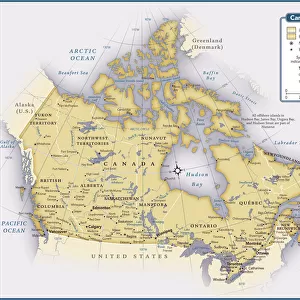
Cartoon map of Canada
Unleash your creativity and transform your space into a visual masterpiece!
Media ID 14637273
12"x10" Modern Frame
Introducing the charming and whimsical Cartoon Map of Canada Framed Print from Media Storehouse's Fine Art Storehouse collection. This delightful artwork adds a touch of playful sophistication to any space. The intricately detailed cartoon map showcases Canada's iconic landmarks and natural wonders in a fun and engaging way. Each print is expertly framed in a sleek, modern frame that complements the vibrant colors and bold lines of the artwork. Bring a piece of Canadian charm into your home or office with this unique and eye-catching framed print.
10x8 Print in an MDF Wooden Frame with 180 gsm Satin Finish Paper. Glazed using shatter proof thin plexi glass. Frame thickness is 1 inch and depth 0.75 inch. Fluted cardboard backing held with clips. Supplied ready to hang with sawtooth hanger and rubber bumpers. Spot clean with a damp cloth. Packaged foam wrapped in a card.
Contemporary Framed and Mounted Prints - Professionally Made and Ready to Hang
Estimated Image Size (if not cropped) is 25.4cm x 25.4cm (10" x 10")
Estimated Product Size is 25.4cm x 30.5cm (10" x 12")
These are individually made so all sizes are approximate
Artwork printed orientated as per the preview above, with landscape (horizontal) or portrait (vertical) orientation to match the source image.
FEATURES IN THESE COLLECTIONS
> Fine Art Storehouse
> Map
> Cartoon Maps
> Maps and Charts
> Related Images
> North America
> Canada
> Maps
> North America
> Canada
> Related Images
EDITORS COMMENTS
This vibrant and whimsical cartoon map of Canada is a delightful piece that captures the essence of this vast and diverse country. Bursting with color, it brings to life the unique characteristics and landmarks that define each province and territory. From coast to coast, this playful illustration showcases iconic symbols such as the majestic Rocky Mountains in Alberta, the stunning Niagara Falls in Ontario, and the picturesque fishing villages of Newfoundland. Each region is depicted with its own distinct charm, highlighting cultural references like hockey players in Quebec or maple syrup production in New Brunswick. The artist's attention to detail is evident throughout this print, as they have carefully crafted every element to create an engaging visual narrative. Whether you're a Canadian proud of your heritage or simply fascinated by our northern neighbor's beauty, this artwork will undoubtedly bring joy and spark conversations. Perfect for any space seeking a touch of lightheartedness or educational flair, this cartoon map invites viewers young and old to explore Canada's rich geography while embracing its playful spirit. Hang it on your wall at home or display it proudly in a classroom setting; either way, it promises endless hours of discovery and appreciation for all things Canadian.
MADE IN THE USA
Safe Shipping with 30 Day Money Back Guarantee
FREE PERSONALISATION*
We are proud to offer a range of customisation features including Personalised Captions, Color Filters and Picture Zoom Tools
SECURE PAYMENTS
We happily accept a wide range of payment options so you can pay for the things you need in the way that is most convenient for you
* Options may vary by product and licensing agreement. Zoomed Pictures can be adjusted in the Cart.