Framed Print > Fine Art Storehouse > Map
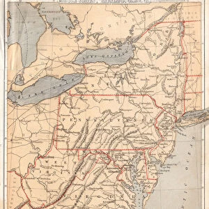
Framed Print : Map of Middle states USA 1883


![]()
Framed Photos from Fine Art Storehouse
Map of Middle states USA 1883
Warrens Common School Geography
Unleash your creativity and transform your space into a visual masterpiece!
THEPALMER
Media ID 13669355
© This content is subject to copyright
Connecticut Maine Massachusetts New Hampshire New Jersey New York State North America Ohio Paper Pennsylvania Rhode Island Virginia Us State
12"x10" Modern Frame
Step back in time with our exquisite 'Map of Middle States USA 1883' Framed Print by THEPALMER from the Media Storehouse Fine Art collection. This captivating vintage map, originally created for Warrens Common School Geography, transports you to an era of exploration and discovery. The intricate details of the map are brought to life in high-quality print, beautifully framed and ready to adorn your walls. Add a touch of history and character to any room with this unique and fascinating piece of American cartography.
10x8 Print in an MDF Wooden Frame with 180 gsm Satin Finish Paper. Glazed using shatter proof thin plexi glass. Frame thickness is 1 inch and depth 0.75 inch. Fluted cardboard backing held with clips. Supplied ready to hang with sawtooth hanger and rubber bumpers. Spot clean with a damp cloth. Packaged foam wrapped in a card.
Contemporary Framed and Mounted Prints - Professionally Made and Ready to Hang
Estimated Image Size (if not cropped) is 25.4cm x 25.4cm (10" x 10")
Estimated Product Size is 30.5cm x 25.4cm (12" x 10")
These are individually made so all sizes are approximate
Artwork printed orientated as per the preview above, with landscape (horizontal) or portrait (vertical) orientation to match the source image.
FEATURES IN THESE COLLECTIONS
> Fine Art Storehouse
> The Magical World of Illustration
> Palmer Illustrated Collection
> Fine Art Storehouse
> Map
> Historical Maps
> Fine Art Storehouse
> Map
> USA Maps
EDITORS COMMENTS
This print of "Map of Middle states USA 1883 (Warrens Common School Geography)" takes us on a journey back in time to the late 19th century. The intricate details and exquisite craftsmanship showcased in this engraving transport us to an era when cartography was both an art form and a scientific endeavor. The map, printed on high-quality paper, depicts the Middle states of the United States as they were known in 1883. From New Hampshire to West Virginia, from Massachusetts to Ohio, each state is meticulously illustrated with its boundaries clearly defined. This antique piece offers a glimpse into the physical geography of these states during that period. The engraved image showcases not only the geographical features but also provides insight into how people perceived and understood their surroundings at that time. It serves as a historical document reflecting the knowledge and advancements made in mapping techniques during that era. Whether you are a history enthusiast or simply appreciate fine art, this print by THEPALMER is sure to captivate your imagination. Hang it on your wall or display it proudly in your study; this map will undoubtedly spark conversations about our ever-changing world and how we have come to understand it over time.
MADE IN THE USA
Safe Shipping with 30 Day Money Back Guarantee
FREE PERSONALISATION*
We are proud to offer a range of customisation features including Personalised Captions, Color Filters and Picture Zoom Tools
SECURE PAYMENTS
We happily accept a wide range of payment options so you can pay for the things you need in the way that is most convenient for you
* Options may vary by product and licensing agreement. Zoomed Pictures can be adjusted in the Cart.