Framed Print > Fine Art Storehouse > Map
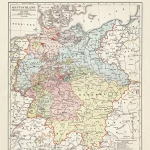
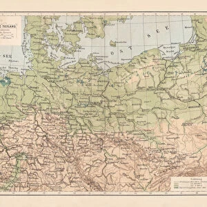
Framed Print : Mecklenburg and Pomerania


![]()
Framed Photos from Fine Art Storehouse
Mecklenburg and Pomerania
Ancient map of Mecklenburg and Pomerania
Unleash your creativity and transform your space into a visual masterpiece!
Nastasic
Media ID 13593315
© Nikola Nastasic
78279 Baltic Sea Berlin Cartographer Contour Drawing European Culture Fischland Darß Zingst German Culture German Empire Island Mecklenburg Vorpommern Poland Polish Culture Pomerania Prussia Rugen Stralsund Topographic Map Topography Deutsches Reich Image Created 19th Century Obsolete Pommern Rugen Island Usedom
12"x10" Modern Frame
Step back in time with our exquisite Framed Print of "Mecklenburg and Pomerania" by Nastasic from our Media Storehouse Fine Art collection. This ancient map transports you to a bygone era, showcasing the intricate details of the regions of Mecklenburg and Pomerania. The rich, vibrant colors and meticulous craftsmanship bring this historical artwork to life, making it a stunning addition to any home or office. Our high-quality framing enhances the beauty of the print, preserving it for generations to come. Bring a piece of history into your space with this captivating Framed Print.
10x8 Print in an MDF Wooden Frame with 180 gsm Satin Finish Paper. Glazed using shatter proof thin plexi glass. Frame thickness is 1 inch and depth 0.75 inch. Fluted cardboard backing held with clips. Supplied ready to hang with sawtooth hanger and rubber bumpers. Spot clean with a damp cloth. Packaged foam wrapped in a card.
Contemporary Framed and Mounted Prints - Professionally Made and Ready to Hang
Estimated Image Size (if not cropped) is 25.4cm x 25.4cm (10" x 10")
Estimated Product Size is 30.5cm x 25.4cm (12" x 10")
These are individually made so all sizes are approximate
Artwork printed orientated as per the preview above, with landscape (horizontal) or portrait (vertical) orientation to match the source image.
FEATURES IN THESE COLLECTIONS
> Fine Art Storehouse
> The Magical World of Illustration
> Nastasic Images & Illustrations
> Fine Art Storehouse
> Map
> Historical Maps
EDITORS COMMENTS
This lithograph print takes us on a journey through time, immersing us in the rich history and cultural heritage of Mecklenburg and Pomerania. Created in the 19th century by renowned cartographer Nastasic, this engraved image showcases the intricate topography of these ancient regions. As our eyes explore the map, we are transported to Rugen Island, Usedom, and Bornholm Island, all nestled within the enchanting Baltic Sea. The contours of each landmass come alive with every stroke of Nastasic's skilled hand, revealing a tapestry woven with German and Polish cultures. The obsolete borders remind us of a different era when Prussia reigned supreme and Berlin was still emerging as an influential capital city. Stralsund stands proudly at its coastal edge while Fischland Darß Zingst beckons us to explore its hidden treasures. Through this horizontal illustration, we glimpse into European culture's past - a mosaic where German traditions intertwine with Polish influences. It serves as both a historical artifact and an artistic masterpiece that captures the essence of Mecklenburg Vorpommern's diverse heritage. Let this print transport you back in time as you marvel at the artistry behind each contour drawing. Discover how centuries-old maps like these continue to shape our understanding of geography while preserving stories from long ago.
MADE IN THE USA
Safe Shipping with 30 Day Money Back Guarantee
FREE PERSONALISATION*
We are proud to offer a range of customisation features including Personalised Captions, Color Filters and Picture Zoom Tools
SECURE PAYMENTS
We happily accept a wide range of payment options so you can pay for the things you need in the way that is most convenient for you
* Options may vary by product and licensing agreement. Zoomed Pictures can be adjusted in the Cart.