Framed Print > Europe > France > Canton > Allier
Framed Print : Antique Map of Gaul


![]()
Framed Photos from Fine Art Storehouse
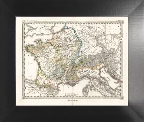
Antique Map of Gaul
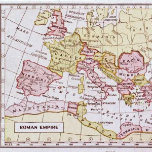
Antique Map from 1862 of Gaul at the time of Julius Caesar. The Roman proconsul and general Julius Caesar pushed his army into Gaul in 58 BC, on the pretext of assisting Romes Gaullish allies against the migrating Helvetii. With the help of various Gallic tribes he managed to conquer nearly all of Gaul. Maps text is written in Latin.
[b]View More:[/b]
[url=http://www.istockphoto.com/file_search.php?action=file&lightboxID=9145610][img]http://www.walker1890.co.uk/istock/istock-map.jpg[/img][/url]
[url=http://www.istockphoto.com/file_search.php?action=file&lightboxID=2789749][img]http://www.walker1890.co.uk/istock/istock-engraving.jpg[/img][/url]
Unleash your creativity and transform your space into a visual masterpiece!
duncan1890
Media ID 21051453
© Duncan Walker
Ancient History Ancient Rome Central Europe Condition Corsica Empire Equipment Historical Geopolitical Location Julius Caesar Latin Script Navigational Equipment Orthographic Symbol Past Roman Rome Royal Person Styles Symbol Classical Style Gaul
12"x10" Modern Frame
Discover the rich history of ancient Gaul with our stunning Framed Antique Map of Gaul from the Media Storehouse Fine Art collection. This exquisite piece, created by the talented artist duncan1890, takes you back in time to 1862, when the Roman world was expanding under the leadership of Julius Caesar. Caesar's conquest of Gaul brought about significant changes to the region, and this map offers a captivating snapshot of its geography and political landscape during that era. Adorn your walls with this beautifully detailed and historically significant artwork, expertly framed to preserve its integrity and enhance its visual appeal. Bring a touch of the past into your home or office with our Framed Antique Map of Gaul from the Media Storehouse Fine Art collection.
10x8 Print in an MDF Wooden Frame with 180 gsm Satin Finish Paper. Glazed using shatter proof thin plexi glass. Frame thickness is 1 inch and depth 0.75 inch. Fluted cardboard backing held with clips. Supplied ready to hang with sawtooth hanger and rubber bumpers. Spot clean with a damp cloth. Packaged foam wrapped in a card.
Contemporary Framed and Mounted Prints - Professionally Made and Ready to Hang
Estimated Image Size (if not cropped) is 25.4cm x 25.4cm (10" x 10")
Estimated Product Size is 30.5cm x 25.4cm (12" x 10")
These are individually made so all sizes are approximate
Artwork printed orientated as per the preview above, with landscape (horizontal) or portrait (vertical) orientation to match the source image.
FEATURES IN THESE COLLECTIONS
> Fine Art Storehouse
> Legends and Icons
> Famous Military Leaders
> Julius Caesar (100 BC-44 BC)
> Fine Art Storehouse
> Map
> Historical Maps
> Arts
> Artists
> R
> Roman Roman
> Europe
> France
> Canton
> Allier
> Europe
> Italy
> Lazio
> Rome
> Europe
> Related Images
> Historic
> Ancient civilizations
> Roman Empire
> Ancient Rome
> Historic
> Ancient civilizations
> Roman Empire
> Roman art
> Historic
> Ancient civilizations
> Roman Empire
> Historic
> Ancient civilizations
> Maps and Charts
> Early Maps
EDITORS COMMENTS
This print showcases an antique map of Gaul from 1862, providing a glimpse into the historical geopolitical landscape at the time of Julius Caesar. The Roman proconsul and general embarked on a military campaign in 58 BC, ostensibly to aid Rome's Gallic allies against migrating Helvetii. However, with the support of various Gallic tribes, Caesar successfully conquered almost all of Gaul. The map itself is a testament to the classical style prevalent during that era, with its Latin script and orthographic symbols. It offers a fascinating insight into ancient civilization and serves as a reminder of the mighty Roman Empire's expansionist ambitions. With meticulous attention to detail, this vintage cartography piece also highlights other significant regions such as Corsica and central Europe. Its old-fashioned charm evokes nostalgia for bygone times while simultaneously piquing curiosity about our shared history. Whether you are an avid history enthusiast or simply appreciate artistry rooted in antiquity, this print transports you back in time. It captures not only the geographical intricacies but also reflects upon the political dynamics that shaped Gaul under Julius Caesar's rule. Displaying this exquisite piece will undoubtedly spark conversations about ancient Rome, its conquests, and how it influenced European history. So immerse yourself in this visual treasure trove – step into Gaul through Julius Caesar's eyes!
MADE IN THE USA
Safe Shipping with 30 Day Money Back Guarantee
FREE PERSONALISATION*
We are proud to offer a range of customisation features including Personalised Captions, Color Filters and Picture Zoom Tools
SECURE PAYMENTS
We happily accept a wide range of payment options so you can pay for the things you need in the way that is most convenient for you
* Options may vary by product and licensing agreement. Zoomed Pictures can be adjusted in the Cart.