Framed Print > Arts > Artists > M > Robert Mitchell
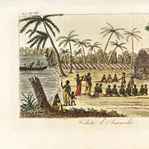
Framed Print : Page 38a Map of S. Andehman Island (pen & ink)
")
")

![]()
Framed Photos from Fine Art Finder
Page 38a Map of S. Andehman Island (pen & ink)
5670305 Page 38a Map of S. Andehman Island (pen & ink) by Unknown artist, (18th century); Mitchell Library, State Library of New South Wales; (add.info.: Original Sketches, Drawings, Maps etc Collected by Admiral Isaac Smith / drawings and watercolours, mainly of Captain Cooks Second Voyage (1772-1775) by William Hodges, Henry Roberts etc
Dimensions: Album measures 49 x 70 cm); Mitchell Library, State Library of New South Wales; out of copyright
Media ID 23584628
© Mitchell Library, State Library of New South Wales / Bridgeman Images
Cartographic Compass Geographical Label Labelled Mapping Monochrome Numbers Scale Survey Surveying
12"x10" Modern Frame
Discover the historical charm of the past with our Framed Prints from Media Storehouse, featuring the intricately detailed Pen & Ink Map of South Andaman Island from Bridgeman Images. This beautiful 18th century artwork, sourced from the Mitchell Library, State Library of New South Wales, adds an elegant touch to any room. With its rich history and timeless design, this Framed Print is a must-have for history enthusiasts and art collectors alike. Order yours today and bring a piece of the past into your home.
10x8 Print in an MDF Wooden Frame with 180 gsm Satin Finish Paper. Glazed using shatter proof thin plexi glass. Frame thickness is 1 inch and depth 0.75 inch. Fluted cardboard backing held with clips. Supplied ready to hang with sawtooth hanger and rubber bumpers. Spot clean with a damp cloth. Packaged foam wrapped in a card.
Contemporary Framed and Mounted Prints - Professionally Made and Ready to Hang
Estimated Image Size (if not cropped) is 25.4cm x 25.4cm (10" x 10")
Estimated Product Size is 25.4cm x 30.5cm (10" x 12")
These are individually made so all sizes are approximate
Artwork printed orientated as per the preview above, with landscape (horizontal) or portrait (vertical) orientation to match the source image.
FEATURES IN THESE COLLECTIONS
> Fine Art Finder
> Artists
> Odilon Redon
> Fine Art Finder
> Artists
> Unknown Artist
> Arts
> Artists
> H
> William Hodges
> Arts
> Artists
> K
> Henry Key
> Arts
> Artists
> M
> Robert Mitchell
> Arts
> Artists
> P
> William Page
> Arts
> Artists
> S
> Robert Smith
> Arts
> Minimalist artwork
> Monochrome artwork
> Fine art
> Arts
> Minimalist artwork
> Monochrome artwork
> Monochrome paintings
> Europe
> United Kingdom
> Wales
> Maps
> Europe
> United Kingdom
> Wales
> Posters
EDITORS COMMENTS
This print showcases a remarkable piece of history, the "Page 38a Map of S. Andehman Island". Created by an unknown artist in the 18th century, this pen and ink map is a testament to the artistry and precision of cartography during that era. The intricate details of this map are truly awe-inspiring. From the carefully drawn coastlines and shorelines to the meticulously labeled physical features, every element has been thoughtfully included. The numbers, key, compass, and scale provide valuable information for navigation and exploration. As we gaze upon this monochrome masterpiece, we can't help but imagine the adventures that took place during Captain Cook's Second Voyage (1772-1775). This map was part of Admiral Isaac Smith's collection and offers us a glimpse into the geographical knowledge available at that time. Measuring 49 x 70 cm within its album, this historic artifact now resides in Mitchell Library at State Library of New South Wales. Its significance lies not only in its artistic beauty but also as a tangible link to our past. Through this print from Fine Art Finder by Bridgeman Images, we are transported back to the XVIIIth century when exploration was at its peak. It serves as a reminder of humanity's insatiable curiosity about our world's coastal regions and maritime boundaries.
MADE IN THE USA
Safe Shipping with 30 Day Money Back Guarantee
FREE PERSONALISATION*
We are proud to offer a range of customisation features including Personalised Captions, Color Filters and Picture Zoom Tools
SECURE PAYMENTS
We happily accept a wide range of payment options so you can pay for the things you need in the way that is most convenient for you
* Options may vary by product and licensing agreement. Zoomed Pictures can be adjusted in the Cart.