Home > Europe > United Kingdom > England > West Sussex > Horsham
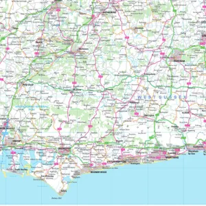
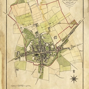
Horsham West Sussex UK City Street Map

![]()
Wall Art and Photo Gifts from Fine Art Storehouse
Horsham West Sussex UK City Street Map
Vector Illustration of a City Street Map of Horsham, West Sussex, UK. Included files are EPS (v10) and Hi-Res JPG.
Data courtesy from Ordnance Survey: VectorMap District
https:/ordnancesurvey.co.uk/business-and-government/products/vectormap-district.html
OS OpenData is free to use under the Open Government Licence (OGL).
Contains OS data eCrown copyright and database right 2017.
http:/nationalarchives.gov.uk/doc/open-government-licence/version/3/
Unleash your creativity and transform your space into a visual masterpiece!
Frank Ramspott
Media ID 15054983
© Frank Ramspott, all rights reserved
Aerial View Computer Graphic Directly Above Gray Green Road Map Street Map Text West Sussex Digitally Generated Image Horsham River Arun
FEATURES IN THESE COLLECTIONS
> Aerial Photography
> Related Images
> Arts
> Landscape paintings
> Waterfall and river artworks
> River artworks
> Arts
> Portraits
> Pop art gallery
> Street art portraits
> Europe
> United Kingdom
> England
> Sussex
> Arun
> Europe
> United Kingdom
> England
> Sussex
> Horsham
> Europe
> United Kingdom
> England
> Sussex
> River
> Europe
> United Kingdom
> England
> West Sussex
> Horsham
> Europe
> United Kingdom
> Maps
> Fine Art Storehouse
> Map
> Street Maps
> Maps and Charts
> Related Images
EDITORS COMMENTS
This stunning print captures the intricate details of Horsham, a charming city in West Sussex, UK. The vector illustration showcases the city's street map with precision and clarity. Created by Frank Ramspott, this digitally generated image is a testament to his exceptional cartography skills. The map includes essential elements such as roads, buildings, and rivers like the picturesque River Arun that flows through Horsham. With its vibrant colors of gray, green, blue, and white, this artwork adds a touch of modernity to any space. Data for this magnificent creation was sourced from Ordnance Survey: VectorMap District - an invaluable resource for accurate mapping information. It's worth noting that OS OpenData allows free usage under the Open Government Licence (OGL), ensuring accessibility to all. Ideal for both residents and visitors alike, this print offers an aerial view directly above Horsham. Its clean design and absence of people allow viewers to focus on the physical geography of the area while appreciating the artistry behind it. Whether you're a fan of maps or simply appreciate beautiful artwork inspired by real locations, this print will undoubtedly enhance your living or working environment with its unique blend of functionality and aesthetics.
MADE IN THE USA
Safe Shipping with 30 Day Money Back Guarantee
FREE PERSONALISATION*
We are proud to offer a range of customisation features including Personalised Captions, Color Filters and Picture Zoom Tools
SECURE PAYMENTS
We happily accept a wide range of payment options so you can pay for the things you need in the way that is most convenient for you
* Options may vary by product and licensing agreement. Zoomed Pictures can be adjusted in the Cart.