Home > Europe > United Kingdom > England > Essex > Grays
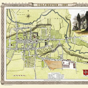
Colchester Essex UK City Street Map

![]()
Wall Art and Photo Gifts from Fine Art Storehouse
Colchester Essex UK City Street Map
Vector Illustration of a City Street Map of Colchester, Essex, UK. Included files are EPS (v10) and Hi-Res JPG.
Data courtesy from Ordnance Survey: VectorMap District
https:/ordnancesurvey.co.uk/business-and-government/products/vectormap-district.html
OS OpenData is free to use under the Open Government Licence (OGL).
Contains OS data eCrown copyright and database right 2017.
http:/nationalarchives.gov.uk/doc/open-government-licence/version/3/
Unleash your creativity and transform your space into a visual masterpiece!
Frank Ramspott
Media ID 15055245
© Frank Ramspott, all rights reserved
Aerial View Computer Graphic Directly Above Essex Gray Green Road Map Street Map Text Colchester Digitally Generated Image River Colne
FEATURES IN THESE COLLECTIONS
> Aerial Photography
> Related Images
> Arts
> Landscape paintings
> Waterfall and river artworks
> River artworks
> Arts
> Portraits
> Pop art gallery
> Street art portraits
> Europe
> United Kingdom
> England
> Essex
> Colchester
> Europe
> United Kingdom
> England
> Essex
> Grays
> Europe
> United Kingdom
> Maps
> Fine Art Storehouse
> Map
> Street Maps
> Maps and Charts
> Related Images
EDITORS COMMENTS
This vibrant and detailed print showcases the city street map of Colchester, Essex, UK. The vector illustration captures the essence of this historic town with precision and accuracy. Created using EPS (v10) and Hi-Res JPG files, this artwork is a testament to the beauty of cartography. The data used in creating this masterpiece is courtesy of Ordnance Survey: VectorMap District, a reliable source for mapping information. It's worth noting that OS OpenData is freely available under the Open Government Licence (OGL), ensuring accessibility for all users. The image features various elements that make up Colchester's urban landscape, including buildings, roads, rivers such as River Colne, and streets. Its design combines digital technology with artistic flair to produce a visually striking composition. With no people present in the picture, viewers can focus solely on appreciating the intricate details presented by this digitally generated image. The color palette incorporates shades of gray, green, blue, and white to create an aesthetically pleasing aerial view directly above Colchester. This print by Frank Ramspott serves as both a functional tool for navigation and an exquisite piece of art that celebrates the physical geography of one of England's oldest towns.
MADE IN THE USA
Safe Shipping with 30 Day Money Back Guarantee
FREE PERSONALISATION*
We are proud to offer a range of customisation features including Personalised Captions, Color Filters and Picture Zoom Tools
SECURE PAYMENTS
We happily accept a wide range of payment options so you can pay for the things you need in the way that is most convenient for you
* Options may vary by product and licensing agreement. Zoomed Pictures can be adjusted in the Cart.