Home > Europe > Germany > Bielefeld
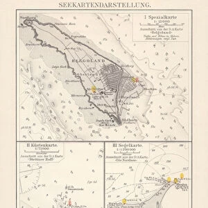
Map of North and East sea 1896

![]()
Wall Art and Photo Gifts from Fine Art Storehouse
Map of North and East sea 1896
Andres Allgemeiner Handatlas - Bielefeld und Leipzig 1896
Unleash your creativity and transform your space into a visual masterpiece!
THEPALMER
Media ID 15133656
© This content is subject to copyright
East Africa Great Britain North North Sea Norway Scandinavia Sweden Traffic
FEATURES IN THESE COLLECTIONS
> Africa
> Related Images
> Europe
> Germany
> Bielefeld
> Fine Art Storehouse
> Map
> Historical Maps
> Maps and Charts
> Early Maps
EDITORS COMMENTS
Map of North and East Sea 1896 captures the essence of a bygone era, offering us a glimpse into the intricate web of maritime routes that once connected nations. This vintage print, sourced from Andres Allgemeiner Handatlas - Bielefeld und Leipzig 1896, takes us on a historical journey through time. With meticulous detail and artistry, THEPALMER's rendition showcases the vast expanse of the North and East Sea regions. From Germany to Great Britain, Norway to Scandinavia, this map highlights key coastal cities and their importance in facilitating trade and communication during this period. The delicate strokes bring forth an air of nostalgia as we explore the sea lanes that were once teeming with bustling traffic. Each line represents countless journeys undertaken by brave sailors navigating treacherous waters in search of adventure or economic prosperity. This piece serves as both an educational tool for geography enthusiasts and a beautiful work of art for any collector. It invites viewers to imagine themselves aboard one of those historic vessels sailing across choppy waves towards distant horizons. Whether displayed in a study or adorning the walls of a maritime enthusiast's home, Map of North and East Sea 1896 is sure to spark curiosity about our shared seafaring heritage.
MADE IN THE USA
Safe Shipping with 30 Day Money Back Guarantee
FREE PERSONALISATION*
We are proud to offer a range of customisation features including Personalised Captions, Color Filters and Picture Zoom Tools
SECURE PAYMENTS
We happily accept a wide range of payment options so you can pay for the things you need in the way that is most convenient for you
* Options may vary by product and licensing agreement. Zoomed Pictures can be adjusted in the Cart.