Home > Arts > Still life artwork > Watercolor paintings > Fine art
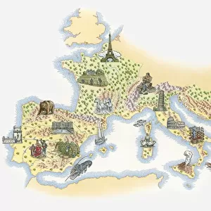
Illustrated map of Bronze Age civilisations across Europe, showing stone circles, settlements, agricultural activity

![]()
Wall Art and Photo Gifts from Fine Art Storehouse
Illustrated map of Bronze Age civilisations across Europe, showing stone circles, settlements, agricultural activity
Unleash your creativity and transform your space into a visual masterpiece!
Dorling Kindersley
Media ID 13540753
© This content is subject to copyright
Ancient Civilisations Ancient History Background People Bronze Age Geography Human Settlement Illustrated Map Incidental People Occupation Stone Circle Working Watercolour Painting
FEATURES IN THESE COLLECTIONS
> Arts
> Still life artwork
> Watercolor paintings
> Fine art
> Europe
> Related Images
> Fine Art Storehouse
> Photo Libraries
> Dorling Kindersley Prints
> Maps and Charts
> Early Maps
EDITORS COMMENTS
This print showcases an intricately illustrated map of Bronze Age civilizations across Europe, offering a fascinating glimpse into the ancient world. The artist has skillfully depicted stone circles, settlements, and agricultural activity that were prevalent during this era. With its watercolor painting style and attention to detail, the map transports viewers back in time to a period characterized by human settlement and cultural development. The horizontal composition allows for a comprehensive view of the European landscape during the Bronze Age. Against a pristine white background, each element stands out vividly, inviting exploration and discovery. This studio shot captures every nuance of the original artwork with precision. As we delve into this historical representation, we are reminded of the rich heritage left behind by our ancestors. From bustling settlements to enigmatic stone circles dotting the land, these remnants tell stories of thriving societies that once flourished across Europe thousands of years ago. Whether you have an interest in ancient civilizations or simply appreciate artistry at its finest, this illustrated map is sure to captivate your imagination. Its vibrant colors and meticulous detailing bring life to an era long gone but not forgotten. With Dorling Kindersley's expertise in producing educational materials on various subjects including history and geography, this print offers both aesthetic pleasure and valuable insights into our past.
MADE IN THE USA
Safe Shipping with 30 Day Money Back Guarantee
FREE PERSONALISATION*
We are proud to offer a range of customisation features including Personalised Captions, Color Filters and Picture Zoom Tools
SECURE PAYMENTS
We happily accept a wide range of payment options so you can pay for the things you need in the way that is most convenient for you
* Options may vary by product and licensing agreement. Zoomed Pictures can be adjusted in the Cart.