Fine Art Print > Universal Images Group (UIG) > Art > Painting, Sculpture & Prints > Cartography
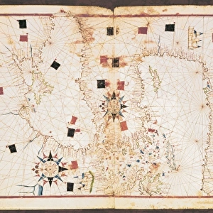
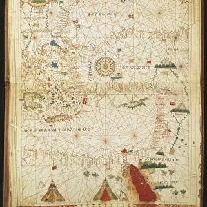
Fine Art Print : Map of Mediterranean Sea, from portolan chart by Pietro Russo, Messina, 1508


![]()
Fine Art Prints From Universal Images Group (UIG)
Map of Mediterranean Sea, from portolan chart by Pietro Russo, Messina, 1508
Cartography, 16th century. Map of the Mediterranean Sea, from a portolan chart by Pietro Russo, Messina, 1508
Universal Images Group (UIG) manages distribution for many leading specialist agencies worldwide
Media ID 9505673
© DEA PICTURE LIBRARY
16th Century Guidance Mediterranean Sea Overhead View Red Background Renaissance
20"x16" (+3" Border) Fine Art Print
Discover the rich history and intrigue of the Mediterranean Sea with our exquisite Fine Art Print from Media Storehouse. This stunning representation is taken from a rare 16th-century Portolan Chart by Pietro Russo of Messina, dated 1508. The meticulously detailed map showcases the Mediterranean's coastlines, islands, and trade routes as they appeared over 500 years ago. Bring the captivating allure of ancient maritime exploration into your home or office with this beautiful, museum-quality print from Universal Images Group.
20x16 image printed on 26x22 Fine Art Rag Paper with 3" (76mm) white border. Our Fine Art Prints are printed on 300gsm 100% acid free, PH neutral paper with archival properties. This printing method is used by museums and art collections to exhibit photographs and art reproductions.
Our fine art prints are high-quality prints made using a paper called Photo Rag. This 100% cotton rag fibre paper is known for its exceptional image sharpness, rich colors, and high level of detail, making it a popular choice for professional photographers and artists. Photo rag paper is our clear recommendation for a fine art paper print. If you can afford to spend more on a higher quality paper, then Photo Rag is our clear recommendation for a fine art paper print.
Estimated Image Size (if not cropped) is 50.8cm x 40.6cm (20" x 16")
Estimated Product Size is 66cm x 55.9cm (26" x 22")
These are individually made so all sizes are approximate
Artwork printed orientated as per the preview above, with landscape (horizontal) orientation to match the source image.
EDITORS COMMENTS
This print showcases a stunning piece of cartographic history - the "Map of Mediterranean Sea" from a portolan chart created by Pietro Russo in Messina, 1508. The vibrant red background adds an intriguing contrast to the intricate details and geographical accuracy depicted on this 16th-century map. In this studio shot, we are presented with an overhead view of the map, allowing us to appreciate its meticulous craftsmanship. The grid lines and guidance markers demonstrate Russo's dedication to precision and his mastery of cartography during the Renaissance period. As we delve into the past through this single object, we are transported back in time to explore Europe's connection with the Mediterranean Sea centuries ago. This historical artifact provides valuable insights into trade routes, navigation techniques, and cultural exchanges that shaped civilizations along these shores. The illustration and painting techniques employed by Pietro Russo bring life to this ancient map while reminding us of its age-old charm. With no people present in the image, our focus is solely directed towards appreciating the artistry behind this remarkable piece. This photograph from Universal Images Group (UIG) serves as a testament to human curiosity about our world's geography throughout different eras. It invites us to reflect upon how far we have come in terms of mapping technology while honoring those who paved the way for our understanding of Earth's landscapes long before satellite imagery became commonplace.
MADE IN THE USA
Safe Shipping with 30 Day Money Back Guarantee
FREE PERSONALISATION*
We are proud to offer a range of customisation features including Personalised Captions, Color Filters and Picture Zoom Tools
SECURE PAYMENTS
We happily accept a wide range of payment options so you can pay for the things you need in the way that is most convenient for you
* Options may vary by product and licensing agreement. Zoomed Pictures can be adjusted in the Basket.