Fine Art Print > Arts > Artists > H > Franz Hogenberg
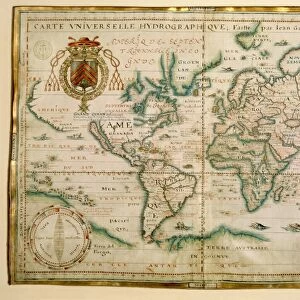
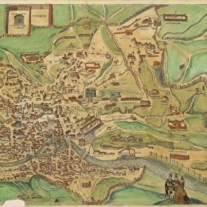
Fine Art Print : Map of Bologna from Civitates Orbis Terrarum by Georg Braun, 1541-1622 and Franz Hogenberg, 1540-1590, engraving


![]()
Fine Art Prints from Universal Images Group (UIG)
Map of Bologna from Civitates Orbis Terrarum by Georg Braun, 1541-1622 and Franz Hogenberg, 1540-1590, engraving
Cartography, Italy, 16th century. Map of Bologna. From Civitates Orbis Terrarum by Georg Braun (1541-1622) and Franz Hogenberg (1540-1590), Cologne. Engraving
Universal Images Group (UIG) manages distribution for many leading specialist agencies worldwide
Media ID 9573149
© DEA / R. MERLO
16th Century Bologna City Map Coat Of Arms Manuscript Surrounding Wall
20"x16" (+3" Border) Fine Art Print
Step back in time with our exquisite Fine Art Print of the Map of Bologna from Civitates Orbis Terrarum. This stunning 16th-century engraving, created by the masterful hands of Georg Braun and Franz Hogenberg, offers a captivating glimpse into the cartography of the past. Delicately etched lines and intricate details bring the city of Bologna to life, transporting you back to the Renaissance era. Add this beautiful work of art to your collection and adorn your walls with a piece of history.
20x16 image printed on 26x22 Fine Art Rag Paper with 3" (76mm) white border. Our Fine Art Prints are printed on 300gsm 100% acid free, PH neutral paper with archival properties. This printing method is used by museums and art collections to exhibit photographs and art reproductions.
Our fine art prints are high-quality prints made using a paper called Photo Rag. This 100% cotton rag fibre paper is known for its exceptional image sharpness, rich colors, and high level of detail, making it a popular choice for professional photographers and artists. Photo rag paper is our clear recommendation for a fine art paper print. If you can afford to spend more on a higher quality paper, then Photo Rag is our clear recommendation for a fine art paper print.
Estimated Image Size (if not cropped) is 50.8cm x 36.2cm (20" x 14.3")
Estimated Product Size is 66cm x 55.9cm (26" x 22")
These are individually made so all sizes are approximate
Artwork printed orientated as per the preview above, with landscape (horizontal) orientation to match the source image.
FEATURES IN THESE COLLECTIONS
> Arts
> Artists
> H
> Franz Hogenberg
> Europe
> Italy
> Emilia-Romagna
> Bologna
> Maps and Charts
> Italy
> Maps and Charts
> Related Images
> Universal Images Group (UIG)
> Art
> Painting, Sculpture & Prints
> Cartography
EDITORS COMMENTS
This print showcases a remarkable piece of history - the Map of Bologna from Civitates Orbis Terrarum by Georg Braun and Franz Hogenberg. Created in the 16th century, this exquisite engraving offers an intricate depiction of Bologna, Italy. The map, meticulously crafted with great attention to detail, provides a fascinating glimpse into the city's physical geography and surrounding wall. Its horizontal composition allows for easy exploration of every nook and cranny within Bologna's boundaries. The inclusion of coat of arms adds an air of regality to this stunning artwork. Displayed in a studio setting, this manuscript exudes an aura that transports viewers back in time to witness the rich history embedded within its lines. It serves as a testament to the skillful artistry and dedication put forth by Braun and Hogenberg. As we delve into this masterpiece, it becomes evident that cartography is not merely about navigation but also an art form capable of evoking emotions. Through their meticulous strokes, Braun and Hogenberg have immortalized Bologna on paper - capturing its essence for generations to come. With no human representation present in the image, one can focus solely on exploring every intricacy presented before them without distraction. This photograph print is a treasure trove for those fascinated by historical maps or anyone seeking inspiration through art rooted in centuries-old craftsmanship.
MADE IN THE USA
Safe Shipping with 30 Day Money Back Guarantee
FREE PERSONALISATION*
We are proud to offer a range of customisation features including Personalised Captions, Color Filters and Picture Zoom Tools
SECURE PAYMENTS
We happily accept a wide range of payment options so you can pay for the things you need in the way that is most convenient for you
* Options may vary by product and licensing agreement. Zoomed Pictures can be adjusted in the Cart.