Fine Art Print > Sheffield City Archives > Maps and Plans > Sheffield OS maps
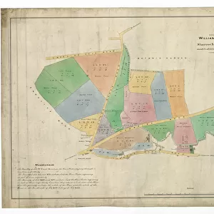
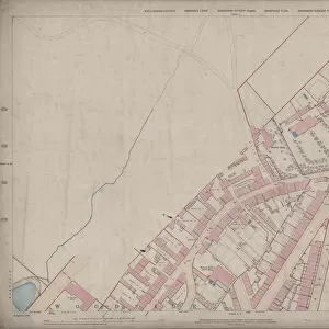
Fine Art Print : Ordnance Survey Map, Gower Street area, Burngreave, Sheffield, 1889 (Yorkshire sheet No. 294. 4. 23)
")


![]()
Fine Art Prints from Sheffield City Archives
Ordnance Survey Map, Gower Street area, Burngreave, Sheffield, 1889 (Yorkshire sheet No. 294. 4. 23)
This map features:
Top left: Buckenham Road, Ditchingham Road, Catherine Road, Granville Street, Grimesthorpe Road, Bressinghham Road, Ellesmere Road, Clun Road, Petre Street, Buckenham Street, Ditchingham Street, School (Boys and Girls), Playground (x2), Temperance Hall, The Garden Cottage Hotel Public House, Tea Garden Terrace, Burngreave House.
Top right: Sutherland Street, Petre Street, Maxwell Street (added in pencil), Writtle Street (added in pencil), Babur Road (added in pencil), Cossey Road (added in pencil), Buckenham Street, Ditchingham Street, [Wesleyan] School (Boys and Girls), [Maxwell Street], Playground (x2), Earsham Street, Thorndon Road, Forncett Street, [Wesleyan] School (Girls), Buckenham Street.
Bottom left: Grimesthorpe Road, Bressinghham Road, Ellesmere Road, Clun Road, Vestry Hall [Burngreave Vestry Hall] Burngreave Road, corner of Grimesthorpe Road, Somerville House, Westbourne House, West Riding Police Station, Burngreave Villas, The Villa, Brunswick Road, Andover Street, Free Library [Burngreave Library], [Wicker] Congregational Church, junction of Ellesmere Road and Burngreave Road School (Boys and Girls), Playground, Earsham Street, Kirk Street, Gower Street, Sorby Street, Clun Street, Gower Arms Public House, Ellesmere Road Post Office.
Bottom right: Earsham Street, Kirk Street, Gower Street, Sorby Street, Clun Street, Thorndon Road, Forncett Street, Carlisle Street East, Carlisle Works, Sutherland Street, Cyclops Works [Charles Cammell and Co. Ltd], Carlisle Street, Norfolk Arms Public House, Sunday School, Methodist Wesleyan Reform Chapel, Gower Street.
Dimensions of original: 77 x 102 cm.
Scale 10.56 feet : 1 mile [1:500].
From an original at Sheffield Libraries: q00045 (sheet No. 294.4.23)
Sheffield City Archives and Local Studies Library has an unrivalled collection of images of Sheffield, England
Media ID 24246509
© Sheffield City Council - All Rights Reserved
Burngreave Old Map Os Map Sheffield Yorkshire
21"x14" (+3" Border) Fine Art Print
Discover the rich history of Sheffield with our exquisite Fine Art Print from Media Storehouse. This captivating piece showcases an Ordnance Survey Map of the Gower Street area in Burngreave, Sheffield, dating back to 1889. Explore the intricate details of the streets, including Buckenham Road, Ditchingham Road, Catherine Road, Granville Street, Grimesthorpe Road, Bressinghham Road, Ellesmere Road, Clun Road, Petre Street, and Buckenham Street. Each print is meticulously produced using high-quality materials, preserving the intricate details and authenticity of the original map from Sheffield City Archives. Bring a piece of history into your home or office with this stunning Fine Art Print from Media Storehouse.
21x14 image printed on 27x20 Fine Art Rag Paper with 3" (76mm) white border. Our Fine Art Prints are printed on 300gsm 100% acid free, PH neutral paper with archival properties. This printing method is used by museums and art collections to exhibit photographs and art reproductions.
Our fine art prints are high-quality prints made using a paper called Photo Rag. This 100% cotton rag fibre paper is known for its exceptional image sharpness, rich colors, and high level of detail, making it a popular choice for professional photographers and artists. Photo rag paper is our clear recommendation for a fine art paper print. If you can afford to spend more on a higher quality paper, then Photo Rag is our clear recommendation for a fine art paper print.
Estimated Image Size (if not cropped) is 53.3cm x 35.5cm (21" x 14")
Estimated Product Size is 68.6cm x 50.8cm (27" x 20")
These are individually made so all sizes are approximate
Artwork printed orientated as per the preview above, with landscape (horizontal) orientation to match the source image.
EDITORS COMMENTS
This print showcases an Ordnance Survey Map of the Gower Street area in Burngreave, Sheffield, dating back to 1889. The map, known as Yorkshire sheet No. 294.4.23, provides a fascinating glimpse into the past and offers a wealth of information about the neighborhood during that time. The top left section of the map reveals streets such as Buckenham Road, Ditchingham Road, Catherine Road, Granville Street, and Grimesthorpe Road. It also highlights notable landmarks like the School for Boys and Girls, two playgrounds, Temperance Hall, and The Garden Cottage Hotel Public House. Moving to the top right corner unveils Sutherland Street, Petre Street, Maxwell Street (added in pencil), Writtle Street (added in pencil), Babur Road (added in pencil), Cossey Road (added in pencil), Wesleyan School for Boys and Girls with its adjacent playgrounds. Other streets featured include Earsham Street and Thorndon Road. The bottom left portion showcases Grimesthorpe Road along with various buildings such as Burngreave Vestry Hall, Somerville House, Westbourne House, and West Riding Police Station among others. Notable locations include Burngreave Library, Wicker Congregational Church, and Ellesmere Road Post Office. Lastly, the bottom right section features Carlisle Works, Cyclops Works, Norfolk Arms Public House, Sunday School, and Methodist Wesleyan Reform Chapel. The presence of Gower Arms Public House adds character to this part of town. Overall, this detailed map measuring 77 x 102 cm at a scale of 10.56 feet:1 mile [1:500] is truly a treasure from Sheffield City Archives that allows us to explore the historical landscape of Burngreave while appreciating its rich heritage
MADE IN THE USA
Safe Shipping with 30 Day Money Back Guarantee
FREE PERSONALISATION*
We are proud to offer a range of customisation features including Personalised Captions, Color Filters and Picture Zoom Tools
SECURE PAYMENTS
We happily accept a wide range of payment options so you can pay for the things you need in the way that is most convenient for you
* Options may vary by product and licensing agreement. Zoomed Pictures can be adjusted in the Cart.