Canvas Print > Sheffield City Archives > Maps and Plans > Sheffield OS maps
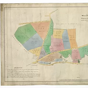
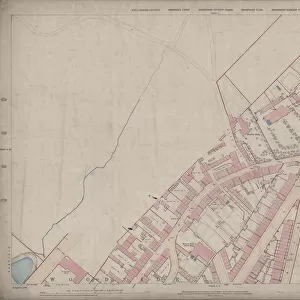
Canvas Print : Ordnance Survey Map, Gower Street area, Burngreave, Sheffield, 1889 (Yorkshire sheet No. 294. 4. 23)
")

")


![]()
Canvas Prints from Sheffield City Archives
Ordnance Survey Map, Gower Street area, Burngreave, Sheffield, 1889 (Yorkshire sheet No. 294. 4. 23)
This map features:
Top left: Buckenham Road, Ditchingham Road, Catherine Road, Granville Street, Grimesthorpe Road, Bressinghham Road, Ellesmere Road, Clun Road, Petre Street, Buckenham Street, Ditchingham Street, School (Boys and Girls), Playground (x2), Temperance Hall, The Garden Cottage Hotel Public House, Tea Garden Terrace, Burngreave House.
Top right: Sutherland Street, Petre Street, Maxwell Street (added in pencil), Writtle Street (added in pencil), Babur Road (added in pencil), Cossey Road (added in pencil), Buckenham Street, Ditchingham Street, [Wesleyan] School (Boys and Girls), [Maxwell Street], Playground (x2), Earsham Street, Thorndon Road, Forncett Street, [Wesleyan] School (Girls), Buckenham Street.
Bottom left: Grimesthorpe Road, Bressinghham Road, Ellesmere Road, Clun Road, Vestry Hall [Burngreave Vestry Hall] Burngreave Road, corner of Grimesthorpe Road, Somerville House, Westbourne House, West Riding Police Station, Burngreave Villas, The Villa, Brunswick Road, Andover Street, Free Library [Burngreave Library], [Wicker] Congregational Church, junction of Ellesmere Road and Burngreave Road School (Boys and Girls), Playground, Earsham Street, Kirk Street, Gower Street, Sorby Street, Clun Street, Gower Arms Public House, Ellesmere Road Post Office.
Bottom right: Earsham Street, Kirk Street, Gower Street, Sorby Street, Clun Street, Thorndon Road, Forncett Street, Carlisle Street East, Carlisle Works, Sutherland Street, Cyclops Works [Charles Cammell and Co. Ltd], Carlisle Street, Norfolk Arms Public House, Sunday School, Methodist Wesleyan Reform Chapel, Gower Street.
Dimensions of original: 77 x 102 cm.
Scale 10.56 feet : 1 mile [1:500].
From an original at Sheffield Libraries: q00045 (sheet No. 294.4.23)
Sheffield City Archives and Local Studies Library has an unrivalled collection of images of Sheffield, England
Media ID 24246509
© Sheffield City Council - All Rights Reserved
Burngreave Old Map Os Map Sheffield Yorkshire
30"x20" (76x51cm) Canvas Print
Step back in time with our stunning Media Storehouse Canvas Print of an historic Ordnance Survey Map from Sheffield City Archives. This captivating print showcases the Gower Street area of Burngreave, Sheffield, as it looked in 1889. With intricate details and precise lines, this map features key streets such as Buckenham Road, Ditchingham Road, Catherine Road, Granville Street, Grimesthorpe Road, Bressinghham Road, Ellesmere Road, Clun Road, Petre Street, and Buckenham Street. Bring the history of Sheffield into your home and add a unique touch to your decor with this beautiful, high-quality canvas print.
Delivered stretched and ready to hang our premium quality canvas prints are made from a polyester/cotton blend canvas and stretched over a 1.25" (32mm) kiln dried knot free wood stretcher bar. Packaged in a plastic bag and secured to a cardboard insert for safe transit.
Canvas Prints add colour, depth and texture to any space. Professionally Stretched Canvas over a hidden Wooden Box Frame and Ready to Hang
Estimated Product Size is 76.2cm x 50.8cm (30" x 20")
These are individually made so all sizes are approximate
Artwork printed orientated as per the preview above, with landscape (horizontal) orientation to match the source image.
EDITORS COMMENTS
This print showcases an Ordnance Survey Map of the Gower Street area in Burngreave, Sheffield, dating back to 1889. The map, known as Yorkshire sheet No. 294.4.23, provides a fascinating glimpse into the past and offers a wealth of information about the neighborhood during that time. The top left section of the map reveals streets such as Buckenham Road, Ditchingham Road, Catherine Road, Granville Street, and Grimesthorpe Road. It also highlights notable landmarks like the School for Boys and Girls, two playgrounds, Temperance Hall, and The Garden Cottage Hotel Public House. Moving to the top right corner unveils Sutherland Street, Petre Street, Maxwell Street (added in pencil), Writtle Street (added in pencil), Babur Road (added in pencil), Cossey Road (added in pencil), Wesleyan School for Boys and Girls with its adjacent playgrounds. Other streets featured include Earsham Street and Thorndon Road. The bottom left portion showcases Grimesthorpe Road along with various buildings such as Burngreave Vestry Hall, Somerville House, Westbourne House, and West Riding Police Station among others. Notable locations include Burngreave Library, Wicker Congregational Church, and Ellesmere Road Post Office. Lastly, the bottom right section features Carlisle Works, Cyclops Works, Norfolk Arms Public House, Sunday School, and Methodist Wesleyan Reform Chapel. The presence of Gower Arms Public House adds character to this part of town. Overall, this detailed map measuring 77 x 102 cm at a scale of 10.56 feet:1 mile [1:500] is truly a treasure from Sheffield City Archives that allows us to explore the historical landscape of Burngreave while appreciating its rich heritage
MADE IN THE USA
Safe Shipping with 30 Day Money Back Guarantee
FREE PERSONALISATION*
We are proud to offer a range of customisation features including Personalised Captions, Color Filters and Picture Zoom Tools
SECURE PAYMENTS
We happily accept a wide range of payment options so you can pay for the things you need in the way that is most convenient for you
* Options may vary by product and licensing agreement. Zoomed Pictures can be adjusted in the Cart.