Fine Art Print > Europe > France > Canton > Landes
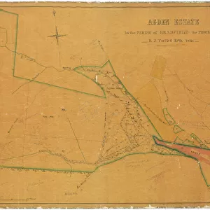
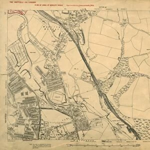
Fine Art Print : Plan of freehold land in the township of Bradfield, parish of Ecclesfield, and county of York, allotted for Sale, by Paul Bright, 1842


![]()
Fine Art Prints From Sheffield City Archives
Plan of freehold land in the township of Bradfield, parish of Ecclesfield, and county of York, allotted for Sale, by Paul Bright, 1842
Scale 6 chains : 1 inch.Size 47 x 38 cm.Original at Local Studies E32S
Sheffield City Archives and Local Studies Library has an unrivalled collection of images of Sheffield, England
Media ID 14048027
© Sheffield City Council
Bradfield Ecclesfield Loxley Maps
20"x16" (+3" Border) Fine Art Print
Discover the historical charm of this exquisite Fine Art Print from Media Storehouse. This rare piece showcases an 1842 Plan of Freehold Land in the township of Bradfield, parish of Ecclesfield, and county of York, meticulously drawn by Paul Bright. Originally housed at Sheffield City Archives, this print offers a fascinating glimpse into the past, providing a unique connection to the rich history of Yorkshire. With intricate details and authenticity, this Fine Art Print makes a stunning addition to any home or office space, perfect for history enthusiasts and collectors alike.
20x16 image printed on 26x22 Fine Art Rag Paper with 3" (76mm) white border. Our Fine Art Prints are printed on 300gsm 100% acid free, PH neutral paper with archival properties. This printing method is used by museums and art collections to exhibit photographs and art reproductions.
Our fine art prints are high-quality prints made using a paper called Photo Rag. This 100% cotton rag fibre paper is known for its exceptional image sharpness, rich colors, and high level of detail, making it a popular choice for professional photographers and artists. Photo rag paper is our clear recommendation for a fine art paper print. If you can afford to spend more on a higher quality paper, then Photo Rag is our clear recommendation for a fine art paper print.
Estimated Image Size (if not cropped) is 50.8cm x 36cm (20" x 14.2")
Estimated Product Size is 66cm x 55.9cm (26" x 22")
These are individually made so all sizes are approximate
Artwork printed orientated as per the preview above, with landscape (horizontal) orientation to match the source image.
FEATURES IN THESE COLLECTIONS
> Europe
> France
> Canton
> Landes
> Maps and Charts
> Related Images
> Sheffield City Archives
> Maps and Plans
EDITORS COMMENTS
This print showcases a historical treasure from the Sheffield City Archives. The image depicts an intricately detailed plan of freehold land in the township of Bradfield, nestled within the picturesque parish of Ecclesfield, located in the county of York. Created by Paul Bright in 1842, this remarkable piece offers a fascinating glimpse into the past. Measuring at an impressive size of 47 x 38 cm, this print is sure to captivate any viewer with its wealth of information and meticulous craftsmanship. The scale used for this plan is six chains to one inch, allowing for precise measurements and accurate representation of the area's layout. The significance of this document lies not only in its cartographic value but also in its potential historical insights. It provides valuable information about land allocation during that time period and sheds light on how communities were structured and organized. Stored within Sheffield's Local Studies collection under reference E32S, this original artifact holds immense cultural importance for those interested in studying ecclesfield history or exploring maps related to bradfield and loxley areas
MADE IN THE USA
Safe Shipping with 30 Day Money Back Guarantee
FREE PERSONALISATION*
We are proud to offer a range of customisation features including Personalised Captions, Color Filters and Picture Zoom Tools
SECURE PAYMENTS
We happily accept a wide range of payment options so you can pay for the things you need in the way that is most convenient for you
* Options may vary by product and licensing agreement. Zoomed Pictures can be adjusted in the Basket.