Fine Art Print > Arts > Artists > P > Polynesian Polynesian
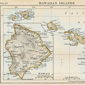
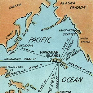
Fine Art Print : Map of Hawaii, 1870s


![]()
Fine Art Prints from North Wind
Map of Hawaii, 1870s
Map of the Hawaiian islands, 1870s.
Color lithograph reproduction of a 19th-century illustration
North Wind Picture Archives brings history to life with stock images and hand-colored illustrations
Media ID 5882575
© North Wind Picture Archives
1870s Hawaii Hawaiian Hawaiian Islands Island Pacific Pacific Island Pacific Ocean Polynesia Polynesian Sandwich Islands
21"x14" (+3" Border) Fine Art Print
Step back in time with our exquisite Fine Art Print from Media Storehouse, featuring a captivating 1870s map of the Hawaiian islands. This stunning, color lithograph reproduction, sourced from the North Wind Picture Archives, transports you to a bygone era with its intricate detail and vibrant hues. Perfect for adding a touch of history and character to your home or office, this fine art print makes a thoughtful gift for history enthusiasts and armchair travelers alike. Experience the rich heritage of the Hawaiian islands through the lens of this beautiful, vintage map.
21x14 image printed on 27x20 Fine Art Rag Paper with 3" (76mm) white border. Our Fine Art Prints are printed on 300gsm 100% acid free, PH neutral paper with archival properties. This printing method is used by museums and art collections to exhibit photographs and art reproductions.
Our fine art prints are high-quality prints made using a paper called Photo Rag. This 100% cotton rag fibre paper is known for its exceptional image sharpness, rich colors, and high level of detail, making it a popular choice for professional photographers and artists. Photo rag paper is our clear recommendation for a fine art paper print. If you can afford to spend more on a higher quality paper, then Photo Rag is our clear recommendation for a fine art paper print.
Estimated Image Size (if not cropped) is 53.3cm x 35.5cm (21" x 14")
Estimated Product Size is 68.6cm x 50.8cm (27" x 20")
These are individually made so all sizes are approximate
Artwork printed orientated as per the preview above, with landscape (horizontal) orientation to match the source image.
FEATURES IN THESE COLLECTIONS
> Arts
> Artists
> O
> Oceanic Oceanic
> Arts
> Artists
> P
> Polynesian Polynesian
> Maps and Charts
> Related Images
> North America
> Related Images
> Popular Themes
> North Island
> North Wind Picture Archives
> Maps
EDITORS COMMENTS
This print showcases a vibrant and historically significant "Map of Hawaii, 1870s". The color lithograph reproduction beautifully captures the essence of this 19th-century illustration, offering viewers a glimpse into the rich heritage and traditional roots of the Hawaiian islands. The map itself is an intricate depiction of the archipelago's geography, showcasing its position in the vast Pacific Ocean. It serves as a testament to Hawaii's unique place within Polynesia and its historical ties to both American and Polynesian cultures. With meticulous detail, this vintage artwork highlights various landmarks and regions that make up the Hawaiian islands. From lush green landscapes to sparkling blue waters, it transports us back in time to experience how these Pacific islands appeared during the late 1800s. As we explore this piece further, we can't help but appreciate its historical significance. It reminds us of Hawaii's journey from being known as Sandwich Islands to becoming an integral part of the United States' history. This artful representation invites us to delve deeper into Hawaiian history while also appreciating it as a work of art. Whether you are fascinated by cartography or simply drawn to vintage illustrations, this Map of Hawaii from North Wind Picture Archives is sure to captivate your imagination with its beauty and cultural importance.
MADE IN THE USA
Safe Shipping with 30 Day Money Back Guarantee
FREE PERSONALISATION*
We are proud to offer a range of customisation features including Personalised Captions, Color Filters and Picture Zoom Tools
SECURE PAYMENTS
We happily accept a wide range of payment options so you can pay for the things you need in the way that is most convenient for you
* Options may vary by product and licensing agreement. Zoomed Pictures can be adjusted in the Cart.