Fine Art Print > Maps and Charts > Americas
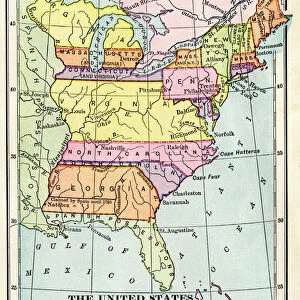
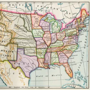
Fine Art Print : United States during the Civil War


![]()
Fine Art Prints from North Wind
United States during the Civil War
Map of the United States 1861 to 1865.
Printed color lithograph of a 19th-century illustration
North Wind Picture Archives brings history to life with stock images and hand-colored illustrations
Media ID 5877464
© North Wind Picture Archives
1860s America Civil War Confederacy North Northern Secession South Southern Territory Confederate States
20"x16" (+3" Border) Fine Art Print
Step back in time with Media Storehouse's exquisite Fine Art Print from North Wind Picture Archives. This captivating 19th-century illustration depicts a map of the United States during the tumultuous period of the Civil War, from 1861 to 1865. Each detail in this printed color lithograph is meticulously rendered, transporting you to a bygone era. Add this historical masterpiece to your home or office to ignite conversations and inspire a deeper appreciation for American history. Experience the past like never before with Media Storehouse's Fine Art Prints.
20x16 image printed on 26x22 Fine Art Rag Paper with 3" (76mm) white border. Our Fine Art Prints are printed on 300gsm 100% acid free, PH neutral paper with archival properties. This printing method is used by museums and art collections to exhibit photographs and art reproductions.
Our fine art prints are high-quality prints made using a paper called Photo Rag. This 100% cotton rag fibre paper is known for its exceptional image sharpness, rich colors, and high level of detail, making it a popular choice for professional photographers and artists. Photo rag paper is our clear recommendation for a fine art paper print. If you can afford to spend more on a higher quality paper, then Photo Rag is our clear recommendation for a fine art paper print.
Estimated Image Size (if not cropped) is 50.8cm x 37.4cm (20" x 14.7")
Estimated Product Size is 66cm x 55.9cm (26" x 22")
These are individually made so all sizes are approximate
Artwork printed orientated as per the preview above, with landscape (horizontal) orientation to match the source image.
FEATURES IN THESE COLLECTIONS
> Maps and Charts
> Related Images
> North America
> Related Images
> South America
> Related Images
> North Wind Picture Archives
> American history
> North Wind Picture Archives
> Maps
EDITORS COMMENTS
This print showcases a vividly colored lithograph of an illustration from the 19th century, depicting the United States during one of its most tumultuous periods - the Civil War. The map, created between 1861 and 1865, offers a fascinating glimpse into American history and serves as a visual representation of this divided nation. The image captures both the northern and southern states, showcasing their distinct territories within North America. It symbolizes not only geographical boundaries but also the ideological divide that led to secession and ultimately sparked this devastating conflict. With intricate details and traditional artistic style, this vintage print transports us back to a time when America was torn apart by differing beliefs on slavery, state rights, and national unity. It serves as a powerful reminder of our nation's complex past while highlighting the struggles faced by both sides during this pivotal era. As we observe this historic illustration with awe-inspiring curiosity, it prompts reflection on how far we have come since those dark days in our history. This artwork invites us to appreciate the resilience shown by Americans throughout generations as they worked towards healing wounds caused by war. Whether displayed in classrooms or historical institutions, this remarkable piece sparks conversations about unity amidst division and reminds us all of our shared heritage – one that continues to shape who we are today.
MADE IN THE USA
Safe Shipping with 30 Day Money Back Guarantee
FREE PERSONALISATION*
We are proud to offer a range of customisation features including Personalised Captions, Color Filters and Picture Zoom Tools
SECURE PAYMENTS
We happily accept a wide range of payment options so you can pay for the things you need in the way that is most convenient for you
* Options may vary by product and licensing agreement. Zoomed Pictures can be adjusted in the Cart.