Fine Art Print > Europe > Spain > Related Images
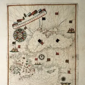
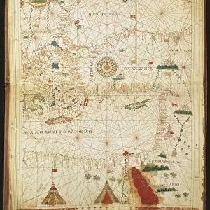
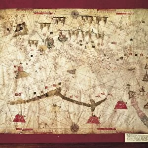
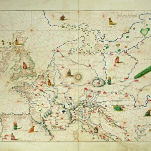
Fine Art Print : Portolan chart, 16th c. Map of the Eastern Mediterranean


![]()
Fine Art Prints From Mary Evans Picture Library
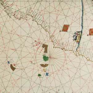
Portolan chart, 16th c. Map of the Eastern Mediterranean
Portolan chart, 16th c. Map of the Eastern Mediterranean Sea and the Black sea. (Anonymous, it is believed to be made by Joan Martines or by his workshop). Renaissance art. Miniature Painting. SPAIN. Barcelona. Barcelona Maritime Museum
Mary Evans Picture Library makes available wonderful images created for people to enjoy over the centuries
Media ID 8276067
© Mary Evans Picture Library 2015 - https://copyrighthub.org/s0/hub1/creation/maryevans/MaryEvansPictureID/10683508
Anonymous Barcelona Believed Chart Joan Martines Mediterranean Portolan Renaissance Workshop Made
20"x16" (+3" Border) Fine Art Print
Discover the captivating allure of the past with our exquisite selection of Fine Art Prints from Media Storehouse, featuring this stunning 16th-century Portolan Chart of the Eastern Mediterranean Sea and the Black Sea. Originating from the Spanish Renaissance, this intricately detailed miniature painting showcases the rich maritime knowledge of the time, with vibrant hues and meticulous brushstrokes that bring history to life. Perfect for adding a touch of timeless elegance to any space, this fine art print is available for rights-managed licensing through Mary Evans Prints Online.
20x16 image printed on 26x22 Fine Art Rag Paper with 3" (76mm) white border. Our Fine Art Prints are printed on 300gsm 100% acid free, PH neutral paper with archival properties. This printing method is used by museums and art collections to exhibit photographs and art reproductions.
Our fine art prints are high-quality prints made using a paper called Photo Rag. This 100% cotton rag fibre paper is known for its exceptional image sharpness, rich colors, and high level of detail, making it a popular choice for professional photographers and artists. Photo rag paper is our clear recommendation for a fine art paper print. If you can afford to spend more on a higher quality paper, then Photo Rag is our clear recommendation for a fine art paper print.
Estimated Image Size (if not cropped) is 50.8cm x 40.6cm (20" x 16")
Estimated Product Size is 66cm x 55.9cm (26" x 22")
These are individually made so all sizes are approximate
Artwork printed orientated as per the preview above, with landscape (horizontal) orientation to match the source image.
MADE IN THE USA
Safe Shipping with 30 Day Money Back Guarantee
FREE PERSONALISATION*
We are proud to offer a range of customisation features including Personalised Captions, Color Filters and Picture Zoom Tools
SECURE PAYMENTS
We happily accept a wide range of payment options so you can pay for the things you need in the way that is most convenient for you
* Options may vary by product and licensing agreement. Zoomed Pictures can be adjusted in the Basket.