Fine Art Print > Africa > Egypt > Cairo
Fine Art Print : Orient Express - Map of the Overland Route to Cairo


![]()
Fine Art Prints From Mary Evans Picture Library
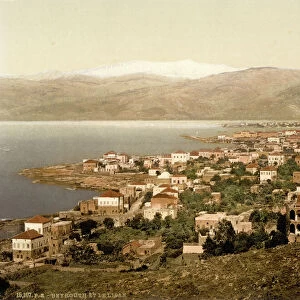
Orient Express - Map of the Overland Route to Cairo
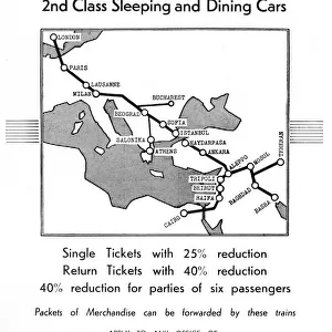
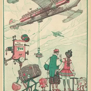
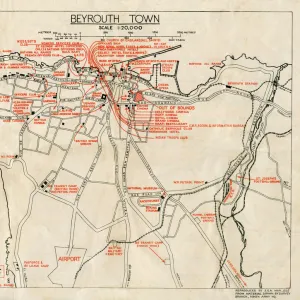
Eliminating the Mediterranean Voyage in the journey to Egypt - The Overland Route to Cairo. The Map of the overland route shows the train line through Western Europe through to Turkey and then through North Syria, Lebanon, Palestine and Egypt. The map shows part of the railway between Tripoli (Lebanon) and Haifa (then Palestine) still uncompleted. Date: April 19 1928
Mary Evans Picture Library makes available wonderful images created for people to enjoy over the centuries
Media ID 14371002
© Illustrated London News Ltd/Mary Evans
Express Mar16 Minor Network Orient Overland Palestine Plan Route Syria Taurus Track
20"x20" (+3" Border) Fine Art Print
Step back in time with our exquisite Fine Art Print from Media Storehouse, featuring the captivating Map of the Overland Route to Cairo from Mary Evans Prints Online. This stunning, rights-managed image eliminates the Mediterranean voyage, instead following the iconic Orient Express as it traverses Western Europe and Turkey. Each print is meticulously produced with the highest quality standards, allowing you to bring the grandeur of the Orient Express into your home or office. Perfect for those who appreciate the rich history of travel and the allure of adventure, this Fine Art Print is a must-have for any collection.
21x7 image printed on 27x13 Fine Art Rag Paper with 3" (76mm) white border. Our Fine Art Prints are printed on 300gsm 100% acid free, PH neutral paper with archival properties. This printing method is used by museums and art collections to exhibit photographs and art reproductions.
Our fine art prints are high-quality prints made using a paper called Photo Rag. This 100% cotton rag fibre paper is known for its exceptional image sharpness, rich colors, and high level of detail, making it a popular choice for professional photographers and artists. Photo rag paper is our clear recommendation for a fine art paper print. If you can afford to spend more on a higher quality paper, then Photo Rag is our clear recommendation for a fine art paper print.
Estimated Image Size (if not cropped) is 37.4cm x 17.7cm (14.7" x 7")
Estimated Product Size is 68.6cm x 33cm (27" x 13")
These are individually made so all sizes are approximate
Artwork printed orientated as per the preview above, with landscape (horizontal) orientation to match the source image.
FEATURES IN THESE COLLECTIONS
> Africa
> Egypt
> Related Images
> Animals
> Mammals
> Bovidae
> Taurus
> Animals
> Mammals
> Muridae
> Western Mediterranean Mouse
> Animals
> Mammals
> Muridae
> Western Mouse
> Arts
> Artists
> S
> Syrian Syrian
> Asia
> Lebanon
> Related Images
EDITORS COMMENTS
This map print depicts the Overland Route to Cairo, an alternative to the traditional Mediterranean voyage for travelers heading to Egypt. Dated April 19, 1928, the map illustrates the Orient Express's railway line traversing Western Europe, Turkey, North Syria, Lebanon, Palestine, and Egypt. The meticulously planned network eliminates the need for a Mediterranean voyage, offering a more direct and intriguing journey through Asia Minor. The map reveals the railway's progression from Europe through the Balkans, Bulgaria, and Romania, continuing on to the Black Sea and the Bosphorus Strait. The route then passes through Anatolia in Turkey, followed by the Middle Eastern countries of North Syria, Lebanon, and Palestine. The map also highlights the part of the railway line between Tripoli, Lebanon, and Haifa, Palestine, which was still under construction at the time. The Overland Route to Cairo represented a significant achievement in the development of international railway networks during the early 20th century. It offered travelers an opportunity to explore diverse cultures and landscapes, bridging the gap between Europe and the Middle East. This map serves as a testament to the ingenuity and ambition of the railway engineers and planners who made this remarkable journey possible.
MADE IN THE USA
Safe Shipping with 30 Day Money Back Guarantee
FREE PERSONALISATION*
We are proud to offer a range of customisation features including Personalised Captions, Color Filters and Picture Zoom Tools
SECURE PAYMENTS
We happily accept a wide range of payment options so you can pay for the things you need in the way that is most convenient for you
* Options may vary by product and licensing agreement. Zoomed Pictures can be adjusted in the Basket.