Fine Art Print > Asia > Iran > Maps
Fine Art Print : Map of the Trabzon Province


![]()
Fine Art Prints from Mary Evans Picture Library
Map of the Trabzon Province
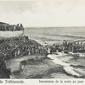
Map showing the Trabzon Province on the Black Sea coast in north-eastern Turkey. The capital of the Province, Trabzon was located on the historic silk road route and during the Ottoman period, because of the importance of its port, Trabzon became a focal point of trade to Iran, India and the Caucasus
Mary Evans Picture Library makes available wonderful images created for people to enjoy over the centuries
Media ID 4419407
© Mary Evans Picture Library 2015 - https://copyrighthub.org/s0/hub1/creation/maryevans/MaryEvansPictureID/10279853
Capital Chart Coast Line Plan Route Script Silk Trabzon Trabzond Trapezium Trebizond Trebizonde Ottoman
21"x14" (+3" Border) Fine Art Print
Discover the rich history and culture of Turkey's Trabzon Province with our exquisite Fine Art Print from Media Storehouse. This stunning Map of Trabzon, sourced from Mary Evans Prints Online, showcases the Black Sea coast province in north-eastern Turkey, including its historic capital city, Trabzon. Once a vital stop on the ancient Silk Road, Trabzon's fascinating past is brought to life through this beautifully detailed, rights-managed print. Add an air of sophistication and intrigue to your home or office décor with this captivating piece of art.
21x14 image printed on 27x20 Fine Art Rag Paper with 3" (76mm) white border. Our Fine Art Prints are printed on 300gsm 100% acid free, PH neutral paper with archival properties. This printing method is used by museums and art collections to exhibit photographs and art reproductions.
Our fine art prints are high-quality prints made using a paper called Photo Rag. This 100% cotton rag fibre paper is known for its exceptional image sharpness, rich colors, and high level of detail, making it a popular choice for professional photographers and artists. Photo rag paper is our clear recommendation for a fine art paper print. If you can afford to spend more on a higher quality paper, then Photo Rag is our clear recommendation for a fine art paper print.
Estimated Image Size (if not cropped) is 51.1cm x 35.5cm (20.1" x 14")
Estimated Product Size is 68.6cm x 50.8cm (27" x 20")
These are individually made so all sizes are approximate
Artwork printed orientated as per the preview above, with landscape (horizontal) orientation to match the source image.
FEATURES IN THESE COLLECTIONS
> Asia
> India
> Related Images
> Asia
> Iran
> Related Images
> Asia
> Turkey
> Related Images
> Maps and Charts
> Early Maps
> Maps and Charts
> India
> Maps and Charts
> Related Images
EDITORS COMMENTS
This map print showcases the Trabzon Province, located on the north-eastern coast of Turkey along the Black Sea. The historic city of Trabzon, the provincial capital, is depicted at the heart of the map. Trabzon holds significant historical importance as it was a crucial stop on the ancient Silk Road trade route. During the Ottoman Empire, the province's strategic location and thriving port made it a focal point for commerce between Iran, India, and the Caucasus regions. The map reveals the intricate details of the province's coastline, roads, and topography. The Black Sea coastline is clearly marked, highlighting the various bays, inlets, and peninsulas that characterize this beautiful region. The roads connecting the various towns and villages within the province are meticulously drawn, providing a glimpse into the transportation network of the past. The map's script is written in a classic, elegant style, adding to its historical charm. The map's title, "Trabzon," is written in both Turkish and the old script used during the Ottoman period. The map also includes the names of various towns and cities within the province, such as Trebizond (another name for Trabzon) and Trapezopolis. The map's historical significance is further emphasized by its depiction of the Trabzon Province during the Ottoman period. The Ottoman Empire's influence is evident in the map's design and the labeling of various landmarks and settlements. The map serves as a testament to the rich history of this region and the vital role it played in the ancient world's trade and commerce.
MADE IN THE USA
Safe Shipping with 30 Day Money Back Guarantee
FREE PERSONALISATION*
We are proud to offer a range of customisation features including Personalised Captions, Color Filters and Picture Zoom Tools
SECURE PAYMENTS
We happily accept a wide range of payment options so you can pay for the things you need in the way that is most convenient for you
* Options may vary by product and licensing agreement. Zoomed Pictures can be adjusted in the Cart.