Fine Art Print > North America > United States of America > New York > New York > Maps
Fine Art Print : Map of New York 1789


![]()
Fine Art Prints from Mary Evans Picture Library
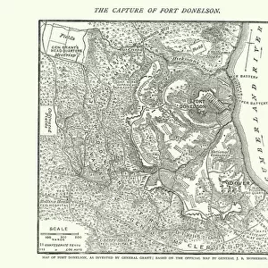
Map of New York 1789
A Plan of the City of New York
Mary Evans Picture Library makes available wonderful images created for people to enjoy over the centuries
Media ID 618373
© Mary Evans Picture Library 2015 - https://copyrighthub.org/s0/hub1/creation/maryevans/MaryEvansPictureID/10086336
21"x14" (+3" Border) Fine Art Print
Discover the rich history of New York City with our exquisite Fine Art Print from the Media Storehouse collection. This stunning representation of "A Plan of the City of New York" dates back to 1789, offering a captivating glimpse into the past. Meticulously sourced from the esteemed Mary Evans Picture Library through Mary Evans Prints Online, this fine art print showcases intricate details of the city's early layout, making it an essential addition to any history or art enthusiast's collection. Bring a piece of New York's fascinating history into your home or office and transport yourself back in time with this beautiful, museum-quality print.
21x14 image printed on 27x20 Fine Art Rag Paper with 3" (76mm) white border. Our Fine Art Prints are printed on 300gsm 100% acid free, PH neutral paper with archival properties. This printing method is used by museums and art collections to exhibit photographs and art reproductions.
Our fine art prints are high-quality prints made using a paper called Photo Rag. This 100% cotton rag fibre paper is known for its exceptional image sharpness, rich colors, and high level of detail, making it a popular choice for professional photographers and artists. Photo rag paper is our clear recommendation for a fine art paper print. If you can afford to spend more on a higher quality paper, then Photo Rag is our clear recommendation for a fine art paper print.
Estimated Image Size (if not cropped) is 53.3cm x 35.5cm (21" x 14")
Estimated Product Size is 68.6cm x 50.8cm (27" x 20")
These are individually made so all sizes are approximate
Artwork printed orientated as per the preview above, with landscape (horizontal) orientation to match the source image.
EDITORS COMMENTS
This stunning print of the "Map of New York 1789 (A Plan of the City of New York)" from Mary Evans Picture Library offers a fascinating glimpse into the historical layout of one of America's most iconic cities. Dating back to the late 18th century, this detailed map showcases the early grid system that would come to define Manhattan's streets and blocks.
As you study this intricate plan, you can almost imagine what life was like in New York City during this time period. The East River is prominently featured, providing a vital waterway for transportation and trade. Nassau Street runs through the heart of the city, offering a bustling thoroughfare for merchants and residents alike.
The precision and artistry displayed in this map are truly remarkable, highlighting both the practicality and beauty inherent in cartography. Each street is meticulously labeled, giving us insight into how urban planning has evolved over centuries.
Whether you're a history buff or simply appreciate fine art, this print is sure to captivate your imagination. It serves as a reminder of New York City's rich past and enduring legacy as a cultural hub. Display it proudly in your home or office to spark conversations about our nation's heritage.
MADE IN THE USA
Safe Shipping with 30 Day Money Back Guarantee
FREE PERSONALISATION*
We are proud to offer a range of customisation features including Personalised Captions, Color Filters and Picture Zoom Tools
FREE COLORIZATION SERVICE
You can choose advanced AI Colorization for this picture at no extra charge!
SECURE PAYMENTS
We happily accept a wide range of payment options so you can pay for the things you need in the way that is most convenient for you
* Options may vary by product and licensing agreement. Zoomed Pictures can be adjusted in the Cart.