Fine Art Print > Maps and Charts > Early Maps
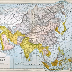
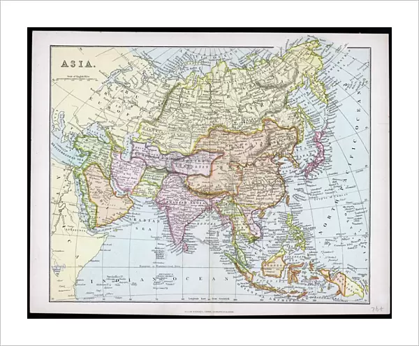
Fine Art Print : MAP / ASIA C1877


![]()
Fine Art Prints from Mary Evans Picture Library
MAP / ASIA C1877
Map of Asia
Mary Evans Picture Library makes available wonderful images created for people to enjoy over the centuries
Media ID 608841
© Mary Evans Picture Library 2015 - https://copyrighthub.org/s0/hub1/creation/maryevans/MaryEvansPictureID/10114143
20"x16" (+3" Border) Fine Art Print
20x16 image printed on 26x22 Fine Art Rag Paper with 3" (76mm) white border. Our Fine Art Prints are printed on 300gsm 100% acid free, PH neutral paper with archival properties. This printing method is used by museums and art collections to exhibit photographs and art reproductions.
Our fine art prints are high-quality prints made using a paper called Photo Rag. This 100% cotton rag fibre paper is known for its exceptional image sharpness, rich colors, and high level of detail, making it a popular choice for professional photographers and artists. Photo rag paper is our clear recommendation for a fine art paper print. If you can afford to spend more on a higher quality paper, then Photo Rag is our clear recommendation for a fine art paper print.
Estimated Image Size (if not cropped) is 50.8cm x 40.6cm (20" x 16")
Estimated Product Size is 66cm x 55.9cm (26" x 22")
These are individually made so all sizes are approximate
Artwork printed orientated as per the preview above, with landscape (horizontal) orientation to match the source image.
FEATURES IN THESE COLLECTIONS
> Asia
> Related Images
> Maps and Charts
> Early Maps
> Maps and Charts
> Related Images
EDITORS COMMENTS
Map of Asia, 1877 (C1877) Description: This historical map print, titled "Map of Asia," dates back to the year 1877 and provides an intriguing glimpse into the geographical knowledge of Asia during that era. The map, which is circa 1877, offers a detailed representation of the Asian continent as it was known at the time. The map is rich in information, depicting the various political boundaries, territories, and geographical features of Asia. The borders of major empires and kingdoms, such as the British Raj, the Russian Empire, the Ottoman Empire, and the Qing Dynasty, are clearly marked. The map also shows the location of major cities, rivers, mountains, and other topographical features. The intricate detail of this map is a testament to the advanced cartographic techniques of the late 19th century. The use of color-coding to distinguish different territories and the inclusion of inset maps of specific regions further enhances the map's utility and accuracy. Historically, this map offers valuable insights into the political and geographical landscape of Asia during the late 19th century, a period marked by intense colonial expansion and the scramble for territories. It provides a fascinating perspective on how Asia was perceived and represented during this time and serves as a reminder of the rich history and diversity of the Asian continent. This map print, which is part of the extensive collection of historical maps at Mary Evans Picture Library, is an essential resource for historians, geographers, and anyone interested in the history of Asia or cartography. Its intricate detail and historical significance make it a valuable addition to any collection or research project.
MADE IN THE USA
Safe Shipping with 30 Day Money Back Guarantee
FREE PERSONALISATION*
We are proud to offer a range of customisation features including Personalised Captions, Color Filters and Picture Zoom Tools
SECURE PAYMENTS
We happily accept a wide range of payment options so you can pay for the things you need in the way that is most convenient for you
* Options may vary by product and licensing agreement. Zoomed Pictures can be adjusted in the Cart.