Fine Art Print > Maps and Charts > Early Maps
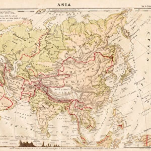
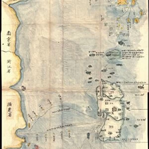
Fine Art Print : MAP / ASIA 1827


![]()
Fine Art Prints from Mary Evans Picture Library
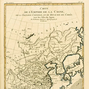
MAP / ASIA 1827
Map of Asia
Mary Evans Picture Library makes available wonderful images created for people to enjoy over the centuries
Media ID 608744
© Mary Evans Picture Library 2015 - https://copyrighthub.org/s0/hub1/creation/maryevans/MaryEvansPictureID/10113732
20"x16" (+3" Border) Fine Art Print
20x16 image printed on 26x22 Fine Art Rag Paper with 3" (76mm) white border. Our Fine Art Prints are printed on 300gsm 100% acid free, PH neutral paper with archival properties. This printing method is used by museums and art collections to exhibit photographs and art reproductions.
Our fine art prints are high-quality prints made using a paper called Photo Rag. This 100% cotton rag fibre paper is known for its exceptional image sharpness, rich colors, and high level of detail, making it a popular choice for professional photographers and artists. Photo rag paper is our clear recommendation for a fine art paper print. If you can afford to spend more on a higher quality paper, then Photo Rag is our clear recommendation for a fine art paper print.
Estimated Image Size (if not cropped) is 49cm x 40.6cm (19.3" x 16")
Estimated Product Size is 66cm x 55.9cm (26" x 22")
These are individually made so all sizes are approximate
Artwork printed orientated as per the preview above, with landscape (horizontal) orientation to match the source image.
FEATURES IN THESE COLLECTIONS
> Asia
> Related Images
> Maps and Charts
> Early Maps
> Maps and Charts
> Related Images
EDITORS COMMENTS
This stunning historical print of a map of Asia from 1827 offers a fascinating glimpse into the past, showcasing the intricate detail and craftsmanship that went into cartography during this time period. The vibrant colors and ornate borders make this map not only informative but also visually captivating.
As we study this map, we are transported back to a time when exploration and discovery were at the forefront of human endeavors. Each country is meticulously outlined, with cities, rivers, and mountain ranges clearly marked. It serves as a reminder of the vastness and diversity of the Asian continent, with its rich cultural heritage and varied landscapes.
Looking at this piece, one can't help but marvel at the skill and dedication required to create such an accurate representation of Asia in the 19th century. It's a testament to human ingenuity and curiosity about the world around us.
Whether you're a history buff or simply appreciate beautiful artwork, this map is sure to spark your imagination and inspire further exploration into the mysteries of Asia's past. Display it proudly in your home or office as a conversation starter or educational tool for all who admire its beauty.
MADE IN THE USA
Safe Shipping with 30 Day Money Back Guarantee
FREE PERSONALISATION*
We are proud to offer a range of customisation features including Personalised Captions, Color Filters and Picture Zoom Tools
SECURE PAYMENTS
We happily accept a wide range of payment options so you can pay for the things you need in the way that is most convenient for you
* Options may vary by product and licensing agreement. Zoomed Pictures can be adjusted in the Cart.