Fine Art Print > Arts > Photorealistic artworks > Meticulous attention to detail > Detailed artwork
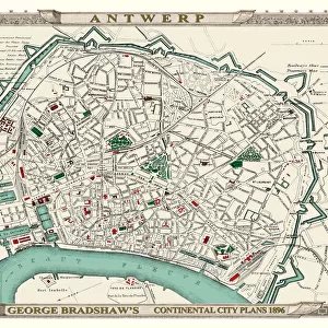
Fine Art Print : George Bradshaws Plan of Antwerp, Belgium 1896


![]()
Fine Art Prints from MapSeeker
George Bradshaws Plan of Antwerp, Belgium 1896
This is a detailed Plan of Antwerp showing the streets, canals, principal buildings, railways and railway stations. There is a numbered key to principal buildings and places of interest. It has been meticulously recreated in colour and republished without and fold creases by Mapseeker, from a rare antique original black and white fold up tourist city map. The 29 that were originally published as fold up maps featuring the principal cities of Europe are now rare, yet popular at their time among those who could then explore Europe by railway for the first time
Welcome to the Mapseeker Image library and enter an historic gateway to one of the largest on-line collections of Historic Maps, Nostalgic Views, Vista's and Panorama's from a World gone by.
Media ID 20347965
© Mapseeker Publishing Ltd
Bradshaw City Map Bradshaw City Plan Bradshaw Map Europe City Europe City Plan European City Map European City Plan Historic Map Old Town Plan Antwerp
21"x14" (+3" Border) Fine Art Print
Discover the rich history and architectural beauty of Antwerp, Belgium with this exquisite Fine Art Print from Media Storehouse and MapSeeker Publishing Ltd. Featuring the meticulously detailed Plan of Antwerp by George Bradshaw, published in 1896, this print showcases the city's intricate network of streets, canals, and principal buildings. Each structure is labeled with a numbered key to enhance your exploration. Bring the past to life and adorn your walls with this captivating piece of cartographic history.
21x14 image printed on 27x20 Fine Art Rag Paper with 3" (76mm) white border. Our Fine Art Prints are printed on 300gsm 100% acid free, PH neutral paper with archival properties. This printing method is used by museums and art collections to exhibit photographs and art reproductions.
Our fine art prints are high-quality prints made using a paper called Photo Rag. This 100% cotton rag fibre paper is known for its exceptional image sharpness, rich colors, and high level of detail, making it a popular choice for professional photographers and artists. Photo rag paper is our clear recommendation for a fine art paper print. If you can afford to spend more on a higher quality paper, then Photo Rag is our clear recommendation for a fine art paper print.
Estimated Image Size (if not cropped) is 53.3cm x 35.5cm (21" x 14")
Estimated Product Size is 68.6cm x 50.8cm (27" x 20")
These are individually made so all sizes are approximate
Artwork printed orientated as per the preview above, with landscape (horizontal) orientation to match the source image.
FEATURES IN THESE COLLECTIONS
> Arts
> Artists
> W
> George White
> Arts
> Modern art pieces
> Pop art
> Street art
> Arts
> Photorealistic artworks
> Detailed art pieces
> Masterful detailing in art
> Arts
> Photorealistic artworks
> Meticulous attention to detail
> Detailed artwork
> Arts
> Photorealistic artworks
> Meticulous attention to detail
> Fine art
> MapSeeker
> Maps of Europe
> Maps of Belgium PORTFOLIO
EDITORS COMMENTS
This beautifully recreated print showcases George Bradshaw's Plan of Antwerp, Belgium in 1896. With meticulous attention to detail, this map provides a comprehensive view of the city's streets, canals, principal buildings, railways, and railway stations. A numbered key accompanies the map, highlighting important landmarks and places of interest. Originally published as fold-up tourist city maps featuring Europe's principal cities, these maps were highly sought after during their time. They allowed adventurous travelers to explore Europe by railway for the first time. Today, only a limited number of these antique originals exist. MapSeeker Publishing Ltd has taken great care in reproducing this rare black and white fold-up map without any fold creases. The vibrant colors breathe new life into this historic piece while preserving its authenticity. Antwerp is captured in all its glory on this old town plan - a testament to its rich history and architectural wonders. As you study the intricacies of this European city plan, you'll be transported back in time to an era when rail travel was revolutionizing how people experienced different cultures. Whether you're a history enthusiast or simply appreciate fine cartography, George Bradshaw's Plan of Antwerp is sure to captivate your imagination and provide valuable insights into the past.
MADE IN THE USA
Safe Shipping with 30 Day Money Back Guarantee
FREE PERSONALISATION*
We are proud to offer a range of customisation features including Personalised Captions, Color Filters and Picture Zoom Tools
SECURE PAYMENTS
We happily accept a wide range of payment options so you can pay for the things you need in the way that is most convenient for you
* Options may vary by product and licensing agreement. Zoomed Pictures can be adjusted in the Cart.