Fine Art Print > Maps and Charts > Related Images
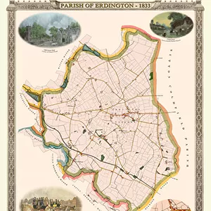
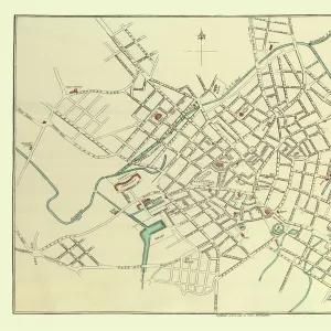
Fine Art Print : Old Map of the Turnpike Road u Erdington 1833 with Stagecoaches at "The Green"


![]()
Fine Art Prints from MapSeeker
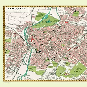
Old Map of the Turnpike Road u Erdington 1833 with Stagecoaches at "The Green"
J130
Welcome to the Mapseeker Image library and enter an historic gateway to one of the largest on-line collections of Historic Maps, Nostalgic Views, Vista's and Panorama's from a World gone by.
Media ID 20348225
Historic Map Old Town Plan Town Plan Erdington Stage Coaches Stagecoach The Green Turnpike
20"x16" (+3" Border) Fine Art Print
Step back in time with our exquisite Old Map of Erdington from the Media Storehouse Fine Art Prints collection. This beautifully detailed 1833 map, sourced from MapSeeker, transports you to a bygone era with its depiction of the Turnpike Road and stagecoaches at "The Green" in Erdington. Each print is meticulously produced using high-quality materials, ensuring vibrant colors and sharp details that bring history to life in your home or office. Add a touch of timeless charm to your space with this captivating piece of historical art.
20x16 image printed on 26x22 Fine Art Rag Paper with 3" (76mm) white border. Our Fine Art Prints are printed on 300gsm 100% acid free, PH neutral paper with archival properties. This printing method is used by museums and art collections to exhibit photographs and art reproductions.
Our fine art prints are high-quality prints made using a paper called Photo Rag. This 100% cotton rag fibre paper is known for its exceptional image sharpness, rich colors, and high level of detail, making it a popular choice for professional photographers and artists. Photo rag paper is our clear recommendation for a fine art paper print. If you can afford to spend more on a higher quality paper, then Photo Rag is our clear recommendation for a fine art paper print.
Estimated Image Size (if not cropped) is 48.7cm x 40.6cm (19.2" x 16")
Estimated Product Size is 66cm x 55.9cm (26" x 22")
These are individually made so all sizes are approximate
Artwork printed orientated as per the preview above, with landscape (horizontal) orientation to match the source image.
FEATURES IN THESE COLLECTIONS
> Maps and Charts
> Related Images
> MapSeeker
> British Town And City Plans
> English & Welsh PORTFOLIO
EDITORS COMMENTS
This print takes us back in time to the year 1833, offering a glimpse into the rich history of Erdington. The image showcases an old map of the Turnpike Road, a vital transportation route during that era. As we delve into this intricate town plan of Erdington, our eyes are immediately drawn to "The Green" a bustling hub where stagecoaches would arrive and depart. The charm of this historic map lies not only in its detailed depiction of roads and landmarks but also in the presence of stagecoaches at "The Green". These iconic vehicles were once the lifeline for travelers, connecting distant towns and villages with their reliable service. Imagining these horse-drawn carriages lining up on Erdington's streets evokes a sense of nostalgia for simpler times. Erdington village itself is beautifully represented on this old town plan. Every street corner seems to hold secrets from centuries past, inviting us to explore further. This snapshot offers more than just geographical information; it encapsulates an entire era within its borders. As we gaze upon this remarkable piece, let us appreciate the efforts made by MapSeeker in preserving such historical gems like this old map of Erdington. It serves as a reminder that beneath our modern surroundings lie stories waiting to be discovered - tales woven by those who traversed these very roads long before us.
MADE IN THE USA
Safe Shipping with 30 Day Money Back Guarantee
FREE PERSONALISATION*
We are proud to offer a range of customisation features including Personalised Captions, Color Filters and Picture Zoom Tools
SECURE PAYMENTS
We happily accept a wide range of payment options so you can pay for the things you need in the way that is most convenient for you
* Options may vary by product and licensing agreement. Zoomed Pictures can be adjusted in the Cart.