Fine Art Print > Arts > Photorealistic artworks > Detailed art pieces > Masterful detailing in art
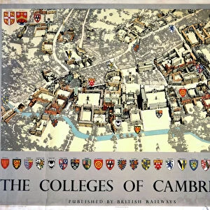
Fine Art Print : Old Map of Cambridge 1804 by Cole and Roper


![]()
Fine Art Prints From MapSeeker
Old Map of Cambridge 1804 by Cole and Roper
An attractive and detailed early 19th century reproduction town plan of Cambridge 1804. First published by Cole and Roper as a finely engraved series of county maps and town plans which were initially issued in parts and then together as The British Atlas in 1810
Welcome to the Mapseeker Image library and enter an historic gateway to one of the largest on-line collections of Historic Maps, Nostalgic Views, Vista's and Panorama's from a World gone by.
Media ID 20348096
© Mapseeker Publishing Ltd
Cole And Roper Historic Map Old Town Plan Town Plan Cambridge Cambridge City
20"x16" (+3" Border) Fine Art Print
Step back in time with our exquisite Old Map of Cambridge 1804 by Cole and Roper from our Fine Art Prints collection at Media Storehouse. This captivating reproduction showcases an intricately detailed town plan of Cambridge as it appeared over 200 years ago. Originally published by Cole and Roper as part of their finely engraved series of county maps, this early 19th century print is a must-have for history enthusiasts, collectors, and those who appreciate the beauty of historical cartography. Bring a piece of the past into your home or office and add a touch of timeless charm to your decor.
20x16 image printed on 26x22 Fine Art Rag Paper with 3" (76mm) white border. Our Fine Art Prints are printed on 300gsm 100% acid free, PH neutral paper with archival properties. This printing method is used by museums and art collections to exhibit photographs and art reproductions.
Our fine art prints are high-quality prints made using a paper called Photo Rag. This 100% cotton rag fibre paper is known for its exceptional image sharpness, rich colors, and high level of detail, making it a popular choice for professional photographers and artists. Photo rag paper is our clear recommendation for a fine art paper print. If you can afford to spend more on a higher quality paper, then Photo Rag is our clear recommendation for a fine art paper print.
Estimated Image Size (if not cropped) is 40.6cm x 50.8cm (16" x 20")
Estimated Product Size is 55.9cm x 66cm (22" x 26")
These are individually made so all sizes are approximate
Artwork printed orientated as per the preview above, with portrait (vertical) orientation to match the source image.
FEATURES IN THESE COLLECTIONS
> Arts
> Photorealistic artworks
> Detailed art pieces
> Masterful detailing in art
> Maps and Charts
> Early Maps
EDITORS COMMENTS
This print showcases an exquisite and meticulously detailed reproduction of the "Old Map of Cambridge 1804" by Cole and Roper. Dating back to the early 19th century, this town plan offers a fascinating glimpse into the historical landscape of Cambridge during that era. Originally published as part of a series of county maps and town plans, Cole and Roper's work stands out for its exceptional engraving technique and attention to detail. The map was initially released in parts before being consolidated into "The British Atlas" in 1810. As you explore this old map, you will be transported back in time to witness the evolution of Cambridge. Every street, building, and landmark is intricately depicted, allowing you to trace the city's development over two centuries ago. From bustling marketplaces to serene college courtyards, this historic map captures the essence of Cambridge's rich heritage. Whether you are a history enthusiast or simply appreciate fine craftsmanship, this print is sure to captivate your imagination. Hang it on your wall or display it proudly on your desk – let it serve as a reminder that even amidst modernity, echoes from our past continue to shape our present-day experiences in this remarkable city called Cambridge.
MADE IN THE USA
Safe Shipping with 30 Day Money Back Guarantee
FREE PERSONALISATION*
We are proud to offer a range of customisation features including Personalised Captions, Color Filters and Picture Zoom Tools
SECURE PAYMENTS
We happily accept a wide range of payment options so you can pay for the things you need in the way that is most convenient for you
* Options may vary by product and licensing agreement. Zoomed Pictures can be adjusted in the Basket.