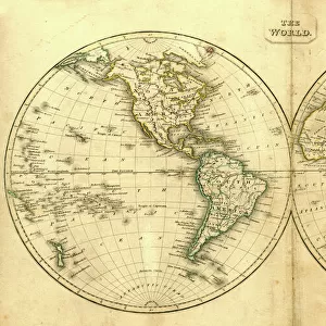
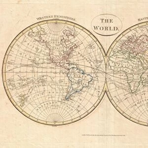
Fine Art Print : 1864, Mitchell Map of the World on Hemisphere Projection, topography, cartography


![]()
Fine Art Prints From Liszt Collection
1864, Mitchell Map of the World on Hemisphere Projection, topography, cartography
1864, Mitchell Map of the World on Hemisphere Projection
Liszt Collection of nineteenth-century engravings and images to browse and enjoy
Media ID 14007891
© Artokoloro Quint Lox Limited
1864 Antique Map Latitude Longitude Mappa Mundi Old Antique Plan Old Antique View Ols Antique Map Rare Old Maps Topo
20"x16" (+3" Border) Fine Art Print
Discover the captivating beauty of history with our Fine Art Print from the Media Storehouse collection. This exquisite piece features the 1864 Mitchell Map of the World on Hemisphere Projection, meticulously reproduced from the renowned Liszt Collection. Delve into the intricacies of topography and cartography as you explore the world as it was depicted over a century ago. Transport yourself back in time with this stunning and authentic work of art, perfect for adding a touch of historical charm to any room in your home or office.
20x16 image printed on 26x22 Fine Art Rag Paper with 3" (76mm) white border. Our Fine Art Prints are printed on 300gsm 100% acid free, PH neutral paper with archival properties. This printing method is used by museums and art collections to exhibit photographs and art reproductions.
Our fine art prints are high-quality prints made using a paper called Photo Rag. This 100% cotton rag fibre paper is known for its exceptional image sharpness, rich colors, and high level of detail, making it a popular choice for professional photographers and artists. Photo rag paper is our clear recommendation for a fine art paper print. If you can afford to spend more on a higher quality paper, then Photo Rag is our clear recommendation for a fine art paper print.
Estimated Image Size (if not cropped) is 47.5cm x 40.6cm (18.7" x 16")
Estimated Product Size is 66cm x 55.9cm (26" x 22")
These are individually made so all sizes are approximate
Artwork printed orientated as per the preview above, with landscape (horizontal) orientation to match the source image.
EDITORS COMMENTS
This print showcases the remarkable "1864, Mitchell Map of the World on Hemisphere Projection". A true masterpiece in topography and cartography, this vintage map takes us back to a time when exploration and discovery were at their peak. The intricate details and precision in illustrating the Earth's geography make it an invaluable piece of historical art. The aged paper adds a touch of nostalgia, reminding us of the rich history that lies within this rare antique map. As we gaze upon its carefully drawn lines depicting latitude and longitude, we are transported to a bygone era where navigation relied on skillful interpretation rather than modern technology. The Mitchell Map invites us to embark on a journey through space and time. It serves as both an educational tool for understanding our planet's regions and as a decorative item that adds character to any space. Its presence evokes curiosity about ancient civilizations' perception of the world they inhabited. As we admire this old-world treasure, let us appreciate not only its aesthetic beauty but also its significance in shaping our understanding of global geography throughout history. The Liszt Collection has preserved this extraordinary piece for all enthusiasts who seek to explore the wonders of our planet from centuries past.
MADE IN THE USA
Safe Shipping with 30 Day Money Back Guarantee
FREE PERSONALISATION*
We are proud to offer a range of customisation features including Personalised Captions, Color Filters and Picture Zoom Tools
SECURE PAYMENTS
We happily accept a wide range of payment options so you can pay for the things you need in the way that is most convenient for you
* Options may vary by product and licensing agreement. Zoomed Pictures can be adjusted in the Basket.