Fine Art Print : 1862, Johnson Map of Florida, topography, cartography, geography, land, illustration


![]()
Fine Art Prints From Liszt Collection
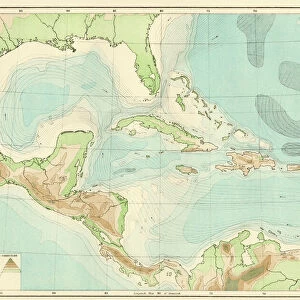
1862, Johnson Map of Florida, topography, cartography, geography, land, illustration
1862, Johnson Map of Florida
Liszt Collection of nineteenth-century engravings and images to browse and enjoy
Media ID 14007728
© Artokoloro Quint Lox Limited
1862 Antique Map Latitude Longitude Mappa Mundi Old Antique Plan Old Antique View Ols Antique Map Rare Old Maps Topo
20"x16" (+3" Border) Fine Art Print
Step back in time with our exquisite selection from the Media Storehouse Fine Art Prints range. This captivating piece showcases the 1862 Johnson Map of Florida, a remarkable illustration from the esteemed Liszt Collection. Delve into the rich history of this region with intricate topography, cartography, and geography details. Bring the beauty of the past into your home or office, and elevate your space with this stunning and authentic work of art.
20x16 image printed on 26x22 Fine Art Rag Paper with 3" (76mm) white border. Our Fine Art Prints are printed on 300gsm 100% acid free, PH neutral paper with archival properties. This printing method is used by museums and art collections to exhibit photographs and art reproductions.
Our fine art prints are high-quality prints made using a paper called Photo Rag. This 100% cotton rag fibre paper is known for its exceptional image sharpness, rich colors, and high level of detail, making it a popular choice for professional photographers and artists. Photo rag paper is our clear recommendation for a fine art paper print. If you can afford to spend more on a higher quality paper, then Photo Rag is our clear recommendation for a fine art paper print.
Estimated Image Size (if not cropped) is 50.3cm x 40.6cm (19.8" x 16")
Estimated Product Size is 66cm x 55.9cm (26" x 22")
These are individually made so all sizes are approximate
Artwork printed orientated as per the preview above, with landscape (horizontal) orientation to match the source image.
EDITORS COMMENTS
This print showcases the 1862 Johnson Map of Florida, a true masterpiece in topography and cartography. With intricate details and precise geographic markings, this vintage illustration takes us back to a time when exploration and discovery shaped our understanding of the world. The map's artistic representation beautifully captures the diverse landscape of Florida, from its lush greenery to its winding rivers and expansive coastline. Its grid-like structure, marked with latitude and longitude lines, provides an invaluable tool for navigation and exploration. As we gaze upon this ancient piece of history, we are transported to a bygone era where paper maps were treasured possessions. The aged appearance adds an extra layer of charm to this decorative artwork that once guided travelers on their journeys across the region. This rare old map is not just a mere historical artifact; it represents mankind's insatiable thirst for knowledge about our planet. It serves as a reminder that even in today's modern age of satellite imagery and GPS systems, there is still something enchanting about studying these antique maps that have stood the test of time. Whether you're an avid collector or simply appreciate the beauty found in old antique plans like this one, this print will undoubtedly add a touch of elegance to any space. Let it transport you back in time as you marvel at the artistry behind mapping our world centuries ago.
MADE IN THE USA
Safe Shipping with 30 Day Money Back Guarantee
FREE PERSONALISATION*
We are proud to offer a range of customisation features including Personalised Captions, Color Filters and Picture Zoom Tools
SECURE PAYMENTS
We happily accept a wide range of payment options so you can pay for the things you need in the way that is most convenient for you
* Options may vary by product and licensing agreement. Zoomed Pictures can be adjusted in the Basket.