Fine Art Print > Africa > Related Images
Fine Art Print : 1847, Levasseur Map of Africa, topography, cartography, geography, land, illustration


![]()
Fine Art Prints From Liszt Collection
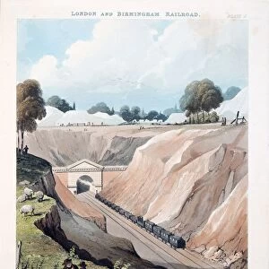
1847, Levasseur Map of Africa, topography, cartography, geography, land, illustration
1847, Levasseur Map of Africa
Liszt Collection of nineteenth-century engravings and images to browse and enjoy
Media ID 14007244
© Artokoloro Quint Lox Limited
1847 Antique Map Latitude Longitude Mappa Mundi Old Antique Plan Old Antique View Ols Antique Map Rare Old Maps Topo
20"x16" (+3" Border) Fine Art Print
Discover the captivating history of Africa with our exquisite 1847 Levasseur Map of Africa Fine Art Print from the esteemed Liszt Collection. This masterpiece of cartography showcases intricate topographical details and geographical landmarks, transporting you back in time. The illustration, a testament to the meticulous craftsmanship of the era, is a must-have for history enthusiasts, geography aficionados, and art collectors alike. Bring the rich tapestry of Africa's past into your home or office with this stunning, museum-quality print.
20x16 image printed on 26x22 Fine Art Rag Paper with 3" (76mm) white border. Our Fine Art Prints are printed on 300gsm 100% acid free, PH neutral paper with archival properties. This printing method is used by museums and art collections to exhibit photographs and art reproductions.
Our fine art prints are high-quality prints made using a paper called Photo Rag. This 100% cotton rag fibre paper is known for its exceptional image sharpness, rich colors, and high level of detail, making it a popular choice for professional photographers and artists. Photo rag paper is our clear recommendation for a fine art paper print. If you can afford to spend more on a higher quality paper, then Photo Rag is our clear recommendation for a fine art paper print.
Estimated Image Size (if not cropped) is 50.8cm x 36.6cm (20" x 14.4")
Estimated Product Size is 66cm x 55.9cm (26" x 22")
These are individually made so all sizes are approximate
Artwork printed orientated as per the preview above, with landscape (horizontal) orientation to match the source image.
EDITORS COMMENTS
This print showcases the intricate and detailed 1847 Levasseur Map of Africa, a true masterpiece in cartography. With its topographical accuracy and geographical precision, this vintage illustration takes us on a journey through time to explore the vast lands and diverse regions of the African continent. The map's artistic charm lies in its decorative elements, reminiscent of ancient world maps. Its aged appearance adds an extra layer of historical significance, reminding us of the rich heritage that lies within these old antique maps. The carefully plotted grid lines, latitude and longitude markers create a sense of order amidst the wild beauty of Africa's landscapes. As we gaze upon this rare piece from the Liszt Collection, we are transported back to an era when exploration was at its peak. It serves as a reminder of how far our knowledge has come since then while also honoring those early adventurers who ventured into uncharted territories. Whether you're a history enthusiast or simply appreciate artful representations of our planet's past, this Levasseur Map is sure to captivate your imagination. Let it take you on an imaginary voyage across Africa's vast plains and majestic mountains as you marvel at the wonders that lie within this ancient land.
MADE IN THE USA
Safe Shipping with 30 Day Money Back Guarantee
FREE PERSONALISATION*
We are proud to offer a range of customisation features including Personalised Captions, Color Filters and Picture Zoom Tools
SECURE PAYMENTS
We happily accept a wide range of payment options so you can pay for the things you need in the way that is most convenient for you
* Options may vary by product and licensing agreement. Zoomed Pictures can be adjusted in the Basket.