Fine Art Print > Europe > United Kingdom > Scotland > Strathclyde > Glasgow
Fine Art Print : Map of Scotland, 1902. Creator: Unknown


![]()
Fine Art Prints From Heritage Images
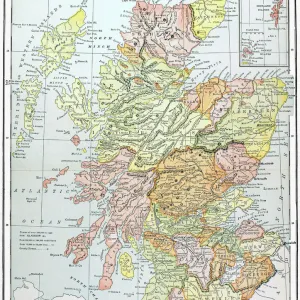
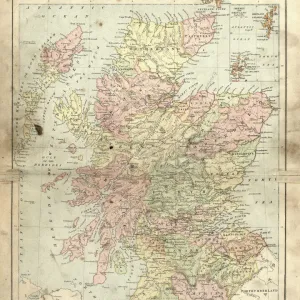
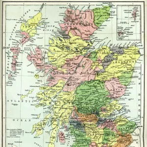
Map of Scotland, 1902. Creator: Unknown
Map of Scotland, 1902. Showing the various counties and islands including the Hebrides, the Shetlands and the Orkneys, and an inset of the rail networks of Glasgow and Edinburgh. From The Century Atlas of the World. [John Walker & Co, Ltd. London, 1902]
Heritage Images features heritage image collections
Media ID 15512564
© The Print Collector / Heritage-Images
Counties County Edinburgh Geographical Institute Hebrides Orkney Islands Orkneys Shetland Islands
20"x16" (+3" Border) Fine Art Print
Discover the rich history and beauty of Scotland with this exquisite Fine Art Print from Media Storehouse. This captivating map, dating back to 1902, showcases the intricate details of Scotland's counties and islands, including the Hebrides, Shetlands, and Orkneys. The inset provides an intriguing glimpse into the rail networks of Glasgow and Edinburgh during that era. A perfect addition to any home or office, this vintage map is a testament to the timeless allure of Scotland's landscape. Created by an unknown artist and sourced from Heritage Images, this Fine Art Print is a must-have for history enthusiasts and those who appreciate the charm of the past.
20x16 image printed on 26x22 Fine Art Rag Paper with 3" (76mm) white border. Our Fine Art Prints are printed on 300gsm 100% acid free, PH neutral paper with archival properties. This printing method is used by museums and art collections to exhibit photographs and art reproductions.
Our fine art prints are high-quality prints made using a paper called Photo Rag. This 100% cotton rag fibre paper is known for its exceptional image sharpness, rich colors, and high level of detail, making it a popular choice for professional photographers and artists. Photo rag paper is our clear recommendation for a fine art paper print. If you can afford to spend more on a higher quality paper, then Photo Rag is our clear recommendation for a fine art paper print.
Estimated Image Size (if not cropped) is 40.6cm x 50.8cm (16" x 20")
Estimated Product Size is 55.9cm x 66cm (22" x 26")
These are individually made so all sizes are approximate
Artwork printed orientated as per the preview above, with portrait (vertical) orientation to match the source image.
FEATURES IN THESE COLLECTIONS
> Europe
> United Kingdom
> Scotland
> Edinburgh
> Edinburgh
> Europe
> United Kingdom
> Scotland
> Edinburgh
> Europe
> United Kingdom
> Scotland
> Glasgow
> Europe
> United Kingdom
> Scotland
> Lothian
> Edinburgh
> Europe
> United Kingdom
> Scotland
> Maps
> Europe
> United Kingdom
> Scotland
> Orkney
> Europe
> United Kingdom
> Scotland
> Posters
> Europe
> United Kingdom
> Scotland
> Related Images
> Europe
> United Kingdom
> Scotland
> Strathclyde
> Glasgow
> Maps and Charts
> Related Images
EDITORS COMMENTS
This print showcases a remarkable piece of history - the Map of Scotland from 1902. Created by an unknown cartographer, this map provides a detailed depiction of the various counties and islands that make up this enchanting country. From the Hebrides to the Shetlands and Orkneys, every corner is meticulously illustrated, offering a glimpse into Scotland's diverse geography. What makes this print even more fascinating is its inclusion of an inset showcasing the rail networks in Glasgow and Edinburgh. This additional detail highlights the importance of transportation during that era and offers insights into how these major cities were connected. The Century Atlas of the World, published by John Walker & Co in London, was renowned for its accuracy and attention to detail. The Edinburgh Geographical Institute played a crucial role in ensuring that this map accurately represented Scotland's geographical features. As we gaze upon this colorful snapshot from over a century ago, we are transported back in time to an era when maps were not just navigational tools but also works of art. With each county carefully delineated and every island precisely marked, it serves as both a historical document and a testament to human curiosity about our world. This print is truly an invaluable treasure for anyone interested in Scottish history or cartography enthusiasts seeking glimpses into past mapping techniques.
MADE IN THE USA
Safe Shipping with 30 Day Money Back Guarantee
FREE PERSONALISATION*
We are proud to offer a range of customisation features including Personalised Captions, Color Filters and Picture Zoom Tools
SECURE PAYMENTS
We happily accept a wide range of payment options so you can pay for the things you need in the way that is most convenient for you
* Options may vary by product and licensing agreement. Zoomed Pictures can be adjusted in the Basket.