Fine Art Print > Europe > United Kingdom > Scotland > Edinburgh > Edinburgh
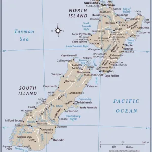
Fine Art Print : Map of Oceania, 1902. Creator: Unknown


![]()
Fine Art Prints From Heritage Images
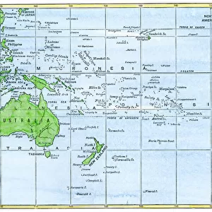
Map of Oceania, 1902. Creator: Unknown
Map of Oceania, 1902. Showing Australia and New Zealand, and the East Indies Archipelago. From The Century Atlas of the World. [John Walker & Co, Ltd. London, 1902]
Heritage Images features heritage image collections
Media ID 15512566
© The Print Collector / Heritage-Images
Archipelago Australia East Indies Edinburgh Geographical Institute Island Islands Micronesia New Zealand Oceania Pacific Ocean
20"x16" (+3" Border) Fine Art Print
Discover the rich history and cultural diversity of Oceania with our exquisite fine art print from Media Storehouse. This beautifully detailed map, created in 1902, showcases the intricate depiction of Australia, New Zealand, and the East Indies Archipelago from The Century Atlas of the World. With its vintage charm and captivating imagery, this unknown masterpiece from Heritage Images is a must-have for history enthusiasts, cartography collectors, and those who appreciate the beauty of the world's geography. Bring a piece of the past into your home or office with this stunning fine art print.
20x16 image printed on 26x22 Fine Art Rag Paper with 3" (76mm) white border. Our Fine Art Prints are printed on 300gsm 100% acid free, PH neutral paper with archival properties. This printing method is used by museums and art collections to exhibit photographs and art reproductions.
Our fine art prints are high-quality prints made using a paper called Photo Rag. This 100% cotton rag fibre paper is known for its exceptional image sharpness, rich colors, and high level of detail, making it a popular choice for professional photographers and artists. Photo rag paper is our clear recommendation for a fine art paper print. If you can afford to spend more on a higher quality paper, then Photo Rag is our clear recommendation for a fine art paper print.
Estimated Image Size (if not cropped) is 50.8cm x 40.6cm (20" x 16")
Estimated Product Size is 66cm x 55.9cm (26" x 22")
These are individually made so all sizes are approximate
Artwork printed orientated as per the preview above, with landscape (horizontal) orientation to match the source image.
FEATURES IN THESE COLLECTIONS
> Arts
> Artists
> O
> Oceanic Oceanic
> Europe
> United Kingdom
> Scotland
> Edinburgh
> Edinburgh
> Europe
> United Kingdom
> Scotland
> Lothian
> Edinburgh
> Maps and Charts
> Related Images
> Maps and Charts
> World
> Oceania
> Federated States of Micronesia
> Maps
> Oceania
> New Zealand
> Maps
> Oceania
> New Zealand
> Related Images
EDITORS COMMENTS
This print showcases a remarkable piece of cartographic history - the "Map of Oceania, 1902". Created by an unknown artist and featured in The Century Atlas of the World, this map provides a fascinating glimpse into the geographical landscape of the early 20th century. The vibrant colors bring to life Australia and New Zealand, two prominent countries within Oceania, as well as the sprawling East Indies Archipelago. With meticulous detail, this map highlights various islands scattered across the Pacific Ocean, including Micronesia. As we delve into this visual treasure trove from John Walker & Co. , Ltd. in London, it becomes evident that every inch has been carefully crafted by experts at Edinburgh Geographical Institute. Their dedication to accuracy is apparent as they accurately depict each country's location and shape. Beyond its aesthetic appeal lies a wealth of historical significance. This map serves as a testament to human curiosity about our world and our desire to explore distant lands. It offers us a window into how people perceived geography over a century ago. Preserved by The Print Collector for future generations to admire, this exceptional print invites us on an enchanting journey through time and space. Whether you are an avid historian or simply captivated by beautiful artwork, this Map of Oceania will undoubtedly leave you awe-inspired with its intricate details and rich hues.
MADE IN THE USA
Safe Shipping with 30 Day Money Back Guarantee
FREE PERSONALISATION*
We are proud to offer a range of customisation features including Personalised Captions, Color Filters and Picture Zoom Tools
SECURE PAYMENTS
We happily accept a wide range of payment options so you can pay for the things you need in the way that is most convenient for you
* Options may vary by product and licensing agreement. Zoomed Pictures can be adjusted in the Basket.