Fine Art Print > Arts > Artists > A > John White Alexander
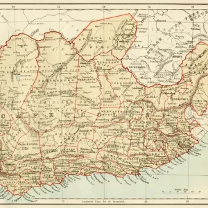
Fine Art Print : Map of Greater Britain in Relation to the Homeland, 1916. Creator: Unknown


![]()
Fine Art Prints from Heritage Images
Map of Greater Britain in Relation to the Homeland, 1916. Creator: Unknown
Map of Greater Britain in Relation to the Homeland, 1916. From " The War Illustrated Album De Luxe - Volume IV. The Summer Campaign - 1915", edited by J. A. Hammerton. [The Amalgamated Press, Limited, London, 1916]
Heritage Images features heritage image collections
Media ID 19661241
© The Print Collector/Heritage Images
Album Amalgamated Press Amalgamated Press Limited Amalgamated Press Ltd British Overseas Territory Distance Distant Great Britain Hammerton Hammerton J A Hammerton Ja Hammerton Sir John Alexander Imperial J A Hammerton Ja Hammerton John Hammerton Measurement Route Sir John Alexander Sir John Alexander Hammerton Sir John Hammerton Summer Campaign 1915 The Amalgamated Press The War Illustrated World Map British Empire
21"x14" (+3" Border) Fine Art Print
Step back in time with our exquisite Fine Art Print of a historic Map of Greater Britain in Relation to the Homeland, dated 1916. This captivating piece, sourced from the pages of "The War Illustrated Album De Luxe - Volume IV," offers a fascinating glimpse into the geopolitical landscape of the early 20th century. Though the creator and publisher remain unknown, the intricate detail and meticulous craftsmanship are evident in every line and border. Bring this piece of history into your home and add a touch of timeless charm to any room. Order now and let this fine art print tell a story that spans generations.
21x14 image printed on 27x20 Fine Art Rag Paper with 3" (76mm) white border. Our Fine Art Prints are printed on 300gsm 100% acid free, PH neutral paper with archival properties. This printing method is used by museums and art collections to exhibit photographs and art reproductions.
Our fine art prints are high-quality prints made using a paper called Photo Rag. This 100% cotton rag fibre paper is known for its exceptional image sharpness, rich colors, and high level of detail, making it a popular choice for professional photographers and artists. Photo rag paper is our clear recommendation for a fine art paper print. If you can afford to spend more on a higher quality paper, then Photo Rag is our clear recommendation for a fine art paper print.
Estimated Image Size (if not cropped) is 53.3cm x 35.5cm (21" x 14")
Estimated Product Size is 68.6cm x 50.8cm (27" x 20")
These are individually made so all sizes are approximate
Artwork printed orientated as per the preview above, with landscape (horizontal) orientation to match the source image.
FEATURES IN THESE COLLECTIONS
> Arts
> Artists
> A
> John White Alexander
> Arts
> Artists
> W
> John White
> Europe
> United Kingdom
> England
> Greater London
> Related Images
> Historic
> World War I and II
> World War I
> Historic
> World War I and II
> Maps and Charts
> British Empire Maps
> Maps and Charts
> Related Images
> Maps and Charts
> World
Map of Greater Britain in Relation to the Homeland, 1916 - A Glimpse into the Vast British Empire during World War I
EDITORS COMMENTS
. This print showcases a remarkable map from 1916, titled "Map of Greater Britain in Relation to the Homeland". Created by an unknown artist, this historical artifact provides us with a unique perspective on the extensive British Empire during the tumultuous era of World War I. The intricate details depicted on this map offer a glimpse into the colonial power that was Great Britain at its zenith. With its vast territories spread across continents and oceans, it symbolizes both imperial ambition and global influence. The image invites viewers to reflect upon concepts such as distance, measurement, and routes that were crucial for maintaining control over such a far-reaching empire. As we delve into this visual representation of history, it becomes apparent how significant this map would have been for understanding strategic military operations during the war. It served as an essential tool for planning campaigns and coordinating efforts across various regions within the empire. Though created more than a century ago, this print continues to captivate our imagination today. It reminds us of Sir John Alexander Hammerton's renowned publication "The War Illustrated Album De Luxe" which chronicled key events during World War I. This particular volume focused on the Summer Campaign of 1915. Through this evocative photograph from Heritage Images' collection, we are transported back in time to witness not only an extraordinary piece of cartography but also gain insight into one of history's most defining periods - World War I - when nations clashed amidst empires striving for dominance.
MADE IN THE USA
Safe Shipping with 30 Day Money Back Guarantee
FREE PERSONALISATION*
We are proud to offer a range of customisation features including Personalised Captions, Color Filters and Picture Zoom Tools
SECURE PAYMENTS
We happily accept a wide range of payment options so you can pay for the things you need in the way that is most convenient for you
* Options may vary by product and licensing agreement. Zoomed Pictures can be adjusted in the Cart.