Fine Art Print > Arts > Minimalist artwork > Monochrome artwork > Fine art
Fine Art Print : Map of County Kilkenny, Ireland, 1924-1926


![]()
Fine Art Prints From Heritage Images
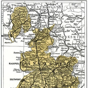
Map of County Kilkenny, Ireland, 1924-1926
Map of County Kilkenny, Ireland, 1924-1926. A print from Hutchinsons Britain Beautiful, edited by Walter Hutchinson, volume III, 1924-1926
Heritage Images features heritage image collections
Media ID 14924071
© The Print Collector / Heritage-Images
Cartography County Ireland Irish Leinster Map Making Kilkenny Print Collector8
20"x16" (+3" Border) Fine Art Print
Step into the past with our exquisite Fine Art Print of a vintage Map of County Kilkenny, Ireland from 1924-1926. Originally published in Hutchinsons Britain Beautiful, edited by Walter Hutchinson, this captivating print showcases intricate cartography and historical detail. A perfect addition to any home or office space, this fine art print is a beautiful representation of Irish heritage and history. Unknown, the creator, masterfully captures the essence of County Kilkenny during this era, making it a must-have for collectors and history enthusiasts alike. Bring a piece of the past into your present with the Media Storehouse range of Fine Art Prints.
20x16 image printed on 26x22 Fine Art Rag Paper with 3" (76mm) white border. Our Fine Art Prints are printed on 300gsm 100% acid free, PH neutral paper with archival properties. This printing method is used by museums and art collections to exhibit photographs and art reproductions.
Our fine art prints are high-quality prints made using a paper called Photo Rag. This 100% cotton rag fibre paper is known for its exceptional image sharpness, rich colors, and high level of detail, making it a popular choice for professional photographers and artists. Photo rag paper is our clear recommendation for a fine art paper print. If you can afford to spend more on a higher quality paper, then Photo Rag is our clear recommendation for a fine art paper print.
Estimated Image Size (if not cropped) is 40.6cm x 48.9cm (16" x 19.3")
Estimated Product Size is 55.9cm x 66cm (22" x 26")
These are individually made so all sizes are approximate
Artwork printed orientated as per the preview above, with portrait (vertical) orientation to match the source image.
FEATURES IN THESE COLLECTIONS
> Arts
> Minimalist artwork
> Monochrome artwork
> Fine art
> Arts
> Minimalist artwork
> Monochrome artwork
> Monochrome paintings
> Europe
> Republic of Ireland
> Maps
> Maps and Charts
> Related Images
EDITORS COMMENTS
This print takes us back in time to the early 20th century, specifically between 1924 and 1926. It showcases a meticulously detailed map of County Kilkenny, Ireland, which was featured in Hutchinsons Britain Beautiful, edited by Walter Hutchinson. The monochrome aesthetic adds an air of nostalgia to this piece of cartography. Every contour line and intricate detail is beautifully captured, allowing us to appreciate the artistry involved in map making during that era. The print provides a glimpse into the geography and location of County Kilkenny within the larger context of Ireland. As we explore this vintage map, we are transported to Leinster province where Kilkenny proudly stands. Its borders are clearly defined as it nestles amidst lush green landscapes and rolling hills. This snapshot from history offers a unique perspective on how our understanding of countries and regions has evolved over time. Although the creator remains unknown, their work has been preserved by The Print Collector - an organization dedicated to safeguarding historical prints for future generations. With no commercial use mentioned here, we can simply marvel at this remarkable piece as a testament to both Irish heritage and the artistry behind map making in the early 20th century.
MADE IN THE USA
Safe Shipping with 30 Day Money Back Guarantee
FREE PERSONALISATION*
We are proud to offer a range of customisation features including Personalised Captions, Color Filters and Picture Zoom Tools
FREE COLORIZATION SERVICE
You can choose advanced AI Colorization for this picture at no extra charge!
SECURE PAYMENTS
We happily accept a wide range of payment options so you can pay for the things you need in the way that is most convenient for you
* Options may vary by product and licensing agreement. Zoomed Pictures can be adjusted in the Basket.