Fine Art Print > Arts > Artists > W > Robert Walker
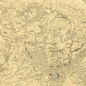
Fine Art Print : Map of the Battle of Carignan, 30 August 1870, (c1872). Creator: R. Walker
. Creator: R. Walker")

![]()
Fine Art Prints From Heritage Images
Map of the Battle of Carignan, 30 August 1870, (c1872). Creator: R. Walker
Map of the Battle of Carignan, 30 August 1870, (c1872). Map: Drawn under the Superintendence of Captain Hozier, showing the enemy positions. The Battle of Carignan took place on the same day as the Battle of Beaumont, in northern France. From " The Franco-Prussian War: its causes, incidents and consequences", Volume I, by Captain H M Hozier. [William Mackenzie, London, 1872]
Heritage Images features heritage image collections
Media ID 19778655
© The Print Collector/Heritage Images
1870 1871 Adversary Bamp W Border Enemy Franco Prussian War Front Line Frontier Frontline H M Hozier Henry Montague Henry Montague Hozier Hozier Lines Mackenzie Meuse Prussia Prussian Prussian Army R Walker River Maas River Meuse Robert Walker Sir Henry Montagu Hozier Walker William Mackenzie Battlefield Carignan
21"x14" (+3" Border) Fine Art Print
Step back in time with our exquisite Fine Art Print of the Battle of Carignan, a captivating historical representation from Heritage Images. Created by R. Walker around 1872, this detailed map showcases the strategic positions of both sides during the pivotal battle on August 30, 1870. Superintended by Captain Hozier, this rare and intriguing piece is a must-have for history enthusiasts and art collectors alike. Bring the rich history of the past into your home or office with our high-quality Fine Art Prints.
21x14 image printed on 27x20 Fine Art Rag Paper with 3" (76mm) white border. Our Fine Art Prints are printed on 300gsm 100% acid free, PH neutral paper with archival properties. This printing method is used by museums and art collections to exhibit photographs and art reproductions.
Our fine art prints are high-quality prints made using a paper called Photo Rag. This 100% cotton rag fibre paper is known for its exceptional image sharpness, rich colors, and high level of detail, making it a popular choice for professional photographers and artists. Photo rag paper is our clear recommendation for a fine art paper print. If you can afford to spend more on a higher quality paper, then Photo Rag is our clear recommendation for a fine art paper print.
Estimated Image Size (if not cropped) is 51.4cm x 35.5cm (20.2" x 14")
Estimated Product Size is 68.6cm x 50.8cm (27" x 20")
These are individually made so all sizes are approximate
Artwork printed orientated as per the preview above, with landscape (horizontal) orientation to match the source image.
FEATURES IN THESE COLLECTIONS
> Arts
> Artists
> D
> William Day
> Arts
> Artists
> W
> Robert Walker
> Arts
> Artists
> W
> Robert White
> Arts
> Artists
> W
> William White
> Europe
> France
> Canton
> Meuse
> Historic
> Battles
> Related Images
> Maps and Charts
> Related Images
EDITORS COMMENTS
This print showcases a historical map titled "Map of the Battle of Carignan, 30 August 1870". Created by R. Walker in approximately 1872, this map was drawn under the supervision of Captain Hozier to depict enemy positions during the battle. The Battle of Carignan occurred on the same day as the Battle of Beaumont in northern France. The map provides a detailed overview of the river, lines, country borders, and geographical features surrounding Carignan. It offers valuable insights into warfare strategies employed by both French and Prussian armies during this significant conflict. As a representation of military history from the late 19th century, it serves as an important resource for understanding armed forces' movements and tactics. This print transports viewers back to a time when nations clashed on European soil. Its monochromatic aesthetic adds an air of nostalgia while highlighting crucial details that would have guided commanders on both sides. The intricate lines and symbols denote frontlines, rivers such as Meuse (also known as Maas), and other key elements essential for comprehending battlefield dynamics. With its rich historical significance captured through Robert Walker's skilled craftsmanship, this print is not only visually appealing but also holds immense educational value for those interested in studying conflicts like the Franco-Prussian War. Preserved within Captain H M Hozier's comprehensive account published in Volume I of "The Franco-Prussian War: its causes, incidents and consequences" this artifact stands testament to human endeavors amidst adversity.
MADE IN THE USA
Safe Shipping with 30 Day Money Back Guarantee
FREE PERSONALISATION*
We are proud to offer a range of customisation features including Personalised Captions, Color Filters and Picture Zoom Tools
SECURE PAYMENTS
We happily accept a wide range of payment options so you can pay for the things you need in the way that is most convenient for you
* Options may vary by product and licensing agreement. Zoomed Pictures can be adjusted in the Basket.