Fine Art Print > Granger Art on Demand > Maps
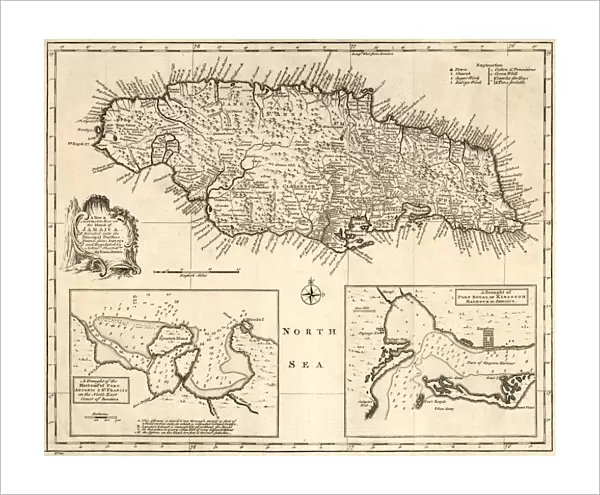
Fine Art Print : MAP: JAMAICA, 1752. British map of the island of Jamaica, divided into its principal parishes


![]()
Fine Art Prints from Granger
MAP: JAMAICA, 1752. British map of the island of Jamaica, divided into its principal parishes
MAP: JAMAICA, 1752.
British map of the island of Jamaica, divided into its principal parishes, published 1752
Granger holds millions of images spanning more than 25,000 years of world history, from before the Stone Age to the dawn of the Space Age
Media ID 12321406
1752 British Island Jamaica Parish Port Royal
20"x16" (+3" Border) Fine Art Print
Discover the rich history of Jamaica with our exquisite fine art print from The Granger Collection. This 1752 British map, titled "Jamaica," offers a captivating glimpse into the past, meticulously detailing the island's principal parishes. The intricate cartography showcases the geographical features and settlements of Jamaica during this era, making it a must-have for history enthusiasts, collectors, or anyone seeking to adorn their space with a piece of historical art. Bring a piece of the past into your home or office with our high-quality fine art print from Media Storehouse.
20x16 image printed on 26x22 Fine Art Rag Paper with 3" (76mm) white border. Our Fine Art Prints are printed on 300gsm 100% acid free, PH neutral paper with archival properties. This printing method is used by museums and art collections to exhibit photographs and art reproductions.
Our fine art prints are high-quality prints made using a paper called Photo Rag. This 100% cotton rag fibre paper is known for its exceptional image sharpness, rich colors, and high level of detail, making it a popular choice for professional photographers and artists. Photo rag paper is our clear recommendation for a fine art paper print. If you can afford to spend more on a higher quality paper, then Photo Rag is our clear recommendation for a fine art paper print.
Estimated Image Size (if not cropped) is 49.8cm x 40.6cm (19.6" x 16")
Estimated Product Size is 66cm x 55.9cm (26" x 22")
These are individually made so all sizes are approximate
Artwork printed orientated as per the preview above, with landscape (horizontal) orientation to match the source image.
EDITORS COMMENTS
This print showcases a remarkable piece of history: the British map of Jamaica from 1752. With its intricate details and sepia tones, this engraving transports us back to a time when cartography was both an art form and a vital tool for exploration. The island of Jamaica is meticulously divided into its principal parishes, offering us a glimpse into the colonial era's administrative divisions. The map highlights the mid-18th century landscape with precision, capturing not only geographical features but also important landmarks such as Port Royal. As we study this historic artifact, we can't help but marvel at the craftsmanship that went into creating it. Published in 1752 by Granger in New York City, this British map serves as a testament to the enduring legacy of cartography and its role in shaping our understanding of the world. It reminds us that maps are more than just navigational aids; they are windows into different times and cultures. Whether you're an avid historian or simply appreciate beautiful artwork, this print is sure to captivate your imagination. Display it proudly on your wall and let it transport you to 18th-century Jamaica—a time when exploration was at its peak and new horizons awaited discovery.
MADE IN THE USA
Safe Shipping with 30 Day Money Back Guarantee
FREE PERSONALISATION*
We are proud to offer a range of customisation features including Personalised Captions, Color Filters and Picture Zoom Tools
SECURE PAYMENTS
We happily accept a wide range of payment options so you can pay for the things you need in the way that is most convenient for you
* Options may vary by product and licensing agreement. Zoomed Pictures can be adjusted in the Cart.