Fine Art Print > Fine Art Storehouse > Map
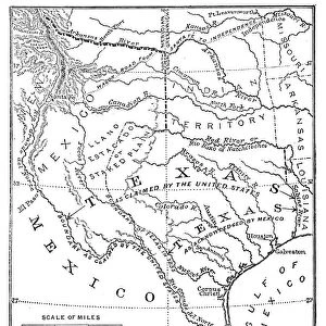
Fine Art Print : United States area: Acquisition and transfer of territory 1780 to 1870


![]()
Fine Art Prints from Fine Art Storehouse
United States area: Acquisition and transfer of territory 1780 to 1870
United States area: Acquisition and transfer of territory 1780 to1870
Unleash your creativity and transform your space into a visual masterpiece!
ivan-96
Media ID 13666965
© ivan-96
Aging Process Animal Markings Arkansas Backgrounds Cartographer Document Gulf Coast States Land Latitude Longitude Louisiana Manuscript Mississippi Monoprint Native American Ethnicity Oklahoma Ornate Pattern Printout Social History Southern Usa Territorial Territorial Animal Texas The Americas Topography Torn Track Imprint Vibrant Color World Map Classical Style Drawing Art Product Obsolete Painted Image Retro Styled Victorian Style
21"x14" (+3" Border) Fine Art Print
Step into history with this captivating Fine Art Print from Media Storehouse, "United States Area: Acquisition and Transfer of Territory 1780 to 1870" by ivan-96. This intricately detailed map illustrates the expansion of the United States from 1780 to 1870, a period marked by significant territorial acquisitions and transfers. With a focus on historical accuracy, this fine art print is not only an educational piece but also a beautiful addition to any home or office space. Transport yourself back in time and explore the rich history of the United States through the lens of this stunning work of art.
21x14 image printed on 27x20 Fine Art Rag Paper with 3" (76mm) white border. Our Fine Art Prints are printed on 300gsm 100% acid free, PH neutral paper with archival properties. This printing method is used by museums and art collections to exhibit photographs and art reproductions.
Our fine art prints are high-quality prints made using a paper called Photo Rag. This 100% cotton rag fibre paper is known for its exceptional image sharpness, rich colors, and high level of detail, making it a popular choice for professional photographers and artists. Photo rag paper is our clear recommendation for a fine art paper print. If you can afford to spend more on a higher quality paper, then Photo Rag is our clear recommendation for a fine art paper print.
Estimated Image Size (if not cropped) is 53.3cm x 33.8cm (21" x 13.3")
Estimated Product Size is 68.6cm x 50.8cm (27" x 20")
These are individually made so all sizes are approximate
Artwork printed orientated as per the preview above, with landscape (horizontal) orientation to match the source image.
FEATURES IN THESE COLLECTIONS
> Fine Art Storehouse
> Map
> Historical Maps
> Fine Art Storehouse
> Map
> USA Maps
> USA Southern States Historical Maps
> Fine Art Storehouse
> Map
> USA Maps
EDITORS COMMENTS
This print titled "United States area: Acquisition and transfer of territory 1780 to 1870" takes us on a visual journey through the historical expansion of the United States. With its vibrant colors and retro styling reminiscent of 19th-century cartography, this piece exudes an antique charm that transports us back in time. The painted image showcases the beauty of nature intertwined with territorial boundaries, capturing the essence of both land and sea. The presence of Native American ethnicity adds depth to this illustration, highlighting the cultural significance embedded within each acquired territory. The intricate details etched into this ornate manuscript-like print depict longitude and latitude lines, providing a comprehensive topographical understanding. As we explore further, we notice the aging process that has given rise to torn patterns across the document, adding a touch of history and authenticity. From Oklahoma to Texas, Louisiana to Mississippi, Arkansas to Southern USA – every region is meticulously portrayed on this world map. The Gulf Coast states are particularly emphasized with their animal markings representing territorial animals native to these areas. Overall, Ivan-96's artwork masterfully combines elements from classical styles with modern photography techniques. This print not only serves as a valuable historical reference but also invites us to appreciate diverse cultures and witness how our nation evolved over time.
MADE IN THE USA
Safe Shipping with 30 Day Money Back Guarantee
FREE PERSONALISATION*
We are proud to offer a range of customisation features including Personalised Captions, Color Filters and Picture Zoom Tools
SECURE PAYMENTS
We happily accept a wide range of payment options so you can pay for the things you need in the way that is most convenient for you
* Options may vary by product and licensing agreement. Zoomed Pictures can be adjusted in the Cart.