Fine Art Print > North America > United States of America > New York > New York > Bridges > Manhattan Bridge
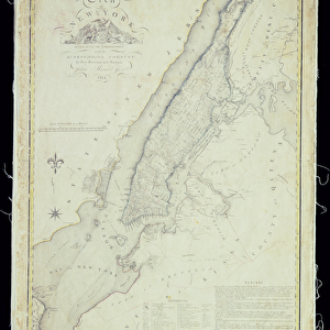
Fine Art Print : Commissioners Map of Manhattan, 1811 (b / w engraving)
")

![]()
Fine Art Prints From Fine Art Finder
Commissioners Map of Manhattan, 1811 (b / w engraving)
3034969 Commissioners Map of Manhattan, 1811 (b/w engraving) by American School, (19th century); (add.info.: The Commissioners Map of Manhattan, created by New York City surveyor William Bridges and published on April 3, 1807; engraving, 1811. The plan determined the modern layout of the island of Manhattan and New York City.); Photo eGraphicaArtis; American, out of copyright
Media ID 22487650
© GraphicaArtis / Bridgeman Images
Blocks Grid Layout Lower Manhattan Manhattan Surveying
20"x16" (+3" Border) Fine Art Print
Discover the rich history of Manhattan with our exquisite Fine Art Print of the Commissioners Map of Manhattan, 1811. This stunning black and white engraving, part of the Bridgeman Images collection from Fine Art Finder, offers a captivating glimpse into the past. Produced by the American School in the 19th century, this detailed map showcases the early development of the city, with its grid pattern of streets and landmarks, including Fort Amsterdam and the Collect Pond. Add this historical masterpiece to your home or office décor and bring a piece of New York City's past into your space.
20x16 image printed on 26x22 Fine Art Rag Paper with 3" (76mm) white border. Our Fine Art Prints are printed on 300gsm 100% acid free, PH neutral paper with archival properties. This printing method is used by museums and art collections to exhibit photographs and art reproductions.
Our fine art prints are high-quality prints made using a paper called Photo Rag. This 100% cotton rag fibre paper is known for its exceptional image sharpness, rich colors, and high level of detail, making it a popular choice for professional photographers and artists. Photo rag paper is our clear recommendation for a fine art paper print. If you can afford to spend more on a higher quality paper, then Photo Rag is our clear recommendation for a fine art paper print.
Estimated Image Size (if not cropped) is 35.7cm x 50.8cm (14.1" x 20")
Estimated Product Size is 55.9cm x 66cm (22" x 26")
These are individually made so all sizes are approximate
Artwork printed orientated as per the preview above, with portrait (vertical) orientation to match the source image.
FEATURES IN THESE COLLECTIONS
> Fine Art Finder
> Artists
> American School
> Maps and Charts
> Related Images
> North America
> United States of America
> New York
> New York
> Bridges
> Manhattan Bridge
> North America
> United States of America
> New York
> New York
> Bridges
> Related Images
> North America
> United States of America
> New York
> New York
> Manhattan
> Related Images
> North America
> United States of America
> New York
> New York
> Maps
> North America
> United States of America
> New York
> Related Images
EDITORS COMMENTS
This engraving captures the historical significance of the Commissioners Map of Manhattan, created by New York City surveyor William Bridges in 1807. Published in 1811, this map played a pivotal role in shaping the modern layout of Manhattan and New York City as we know it today. The intricate details showcased in this print highlight the meticulous work that went into surveying and planning the island. Every block, every street, and every corner is meticulously laid out on this antique grid-like map. It serves as a testament to the precision and foresight of Bridges' vision for urban development. As you gaze upon this image, you can't help but imagine what Lower Manhattan looked like during those early years. The streets were not yet bustling with skyscrapers or crowded with cars; instead, they were lined with modest buildings and horse-drawn carriages. This print allows us to step back in time and appreciate how much has changed over two centuries while also acknowledging how certain elements have remained constant throughout history. It offers a unique glimpse into the past while reminding us of our connection to those who came before us. Whether you are a history enthusiast or simply captivated by cartography, this Commissioners Map of Manhattan engraving is sure to spark your curiosity about New York City's rich heritage.
MADE IN THE USA
Safe Shipping with 30 Day Money Back Guarantee
FREE PERSONALISATION*
We are proud to offer a range of customisation features including Personalised Captions, Color Filters and Picture Zoom Tools
SECURE PAYMENTS
We happily accept a wide range of payment options so you can pay for the things you need in the way that is most convenient for you
* Options may vary by product and licensing agreement. Zoomed Pictures can be adjusted in the Basket.