Fine Art Print > North America > United States of America > New York > New York > Maps
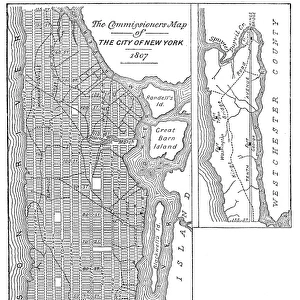
Fine Art Print : Map of the City of New York as Laid Out by the Commissioners, 1814

![]()
Fine Art Prints From Fine Art Finder
Map of the City of New York as Laid Out by the Commissioners, 1814
NYH192080 Map of the City of New York as Laid Out by the Commissioners, 1814 by Randel, John Jr. (fl.c.1807-14); Collection of the New-York Historical Society, USA; (add.info.: known as the Commissioners Plan; Randel was made a survey of the whole of Manhattan; beginning of gridiron layout of streets of Upper Manhattan; approved by state legislature 1811; ); eNew York Historical Society; American, out of copyright
Media ID 22339740
© New York Historical Society / Bridgeman Images
East Coast Grid Urban Planning
21"x14" (+3" Border) Fine Art Print
Discover the rich history of New York City with this stunning Fine Art Print from Media Storehouse and Bridgeman Images. Depicting a map of the City of New York as it was laid out by the Commissioners in 1814, this exquisite print showcases the intricate details of the city's early development. Captured by renowned cartographer John Randel Jr., this map offers a fascinating glimpse into the past, making it a must-have for history enthusiasts and art collectors alike. Bring a piece of New York's rich history into your home or office with this beautiful and authentic Fine Art Print from Media Storehouse and Fine Art Finder.
21x14 image printed on 27x20 Fine Art Rag Paper with 3" (76mm) white border. Our Fine Art Prints are printed on 300gsm 100% acid free, PH neutral paper with archival properties. This printing method is used by museums and art collections to exhibit photographs and art reproductions.
Our fine art prints are high-quality prints made using a paper called Photo Rag. This 100% cotton rag fibre paper is known for its exceptional image sharpness, rich colors, and high level of detail, making it a popular choice for professional photographers and artists. Photo rag paper is our clear recommendation for a fine art paper print. If you can afford to spend more on a higher quality paper, then Photo Rag is our clear recommendation for a fine art paper print.
Estimated Image Size (if not cropped) is 35.5cm x 51.4cm (14" x 20.2")
Estimated Product Size is 50.8cm x 68.6cm (20" x 27")
These are individually made so all sizes are approximate
Artwork printed orientated as per the preview above, with portrait (vertical) orientation to match the source image.
FEATURES IN THESE COLLECTIONS
> Fine Art Finder
> Artists
> American Photographer (after)
> Fine Art Finder
> Artists
> John Jr. Randel
> Fine Art Finder
> Maps (celestial & Terrestrial)
> Arts
> Portraits
> Pop art gallery
> Street art portraits
> Maps and Charts
> Early Maps
> Maps and Charts
> Related Images
> North America
> United States of America
> Maps
> North America
> United States of America
> New York
> New York
> Manhattan
> Related Images
> North America
> United States of America
> New York
> New York
> Maps
> North America
> United States of America
> New York
> Related Images
EDITORS COMMENTS
This print showcases the "Map of the City of New York as Laid Out by the Commissioners, 1814" created by John Randel Jr. This map, also known as the Commissioners Plan, was a groundbreaking urban planning project that shaped the future development of Manhattan. In this meticulously detailed map, Randel presents his survey of the entire island of Manhattan, revealing a gridiron layout that would become iconic to New York City's streetscape. Approved by the state legislature in 1811, this visionary plan revolutionized urban design and set a precedent for cities across America. The Map of the City of New York offers us a glimpse into history and allows us to appreciate Randel's remarkable foresight. It captures an important moment in time when Manhattan was on the cusp of transformation and growth. As we study this image closely, we can't help but marvel at how far New York City has come since its early beginnings. The bustling metropolis we know today owes much to Randel's pioneering work and his dedication to creating an organized cityscape. This print serves as both a historical artifact and a testament to human ingenuity. It reminds us that even centuries ago, individuals like John Randel Jr. were shaping our world with their innovative ideas. As we gaze upon this piece from Fine Art Finder, let it inspire us to continue pushing boundaries and envisioning new possibilities for our own cities' futures.
MADE IN THE USA
Safe Shipping with 30 Day Money Back Guarantee
FREE PERSONALISATION*
We are proud to offer a range of customisation features including Personalised Captions, Color Filters and Picture Zoom Tools
SECURE PAYMENTS
We happily accept a wide range of payment options so you can pay for the things you need in the way that is most convenient for you
* Options may vary by product and licensing agreement. Zoomed Pictures can be adjusted in the Basket.