Fine Art Print > Aerial Photography > Austria
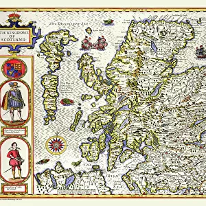
Fine Art Print : Map of the Siege of Mantua, published by William Blackwood and Sons, Edinburgh & London


![]()
Fine Art Prints From Fine Art Finder
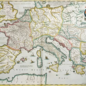
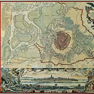
Map of the Siege of Mantua, published by William Blackwood and Sons, Edinburgh & London
746934 Map of the Siege of Mantua, published by William Blackwood and Sons, Edinburgh & London, 1848 (hand-coloured engraving) by Johnston, Alexander Keith (1804-71); Private Collection; (add.info.: Siege of Mantua (1796-97)
); The Stapleton Collection; Scottish, out of copyright
Media ID 23484072
© The Stapleton Collection / Bridgeman Images
Aerial View Armies French Revolutionary Wars Mapping Napoleon Positions War Of The First Coalition Italian Campaigns
20"x16" (+3" Border) Fine Art Print
Step back in time with our exquisite Map of the Siege of Mantua from the Media Storehouse Fine Art Prints collection. Published by William Blackwood and Sons in 1848, this hand-coloured engraving by Johnston is a captivating piece of historical art. The intricate detailing and vibrant colours bring to life the strategic layout of the siege, providing a fascinating glimpse into the past. Add this beautiful print to your home or office to inspire curiosity and ignite conversations about the rich history of Europe. Order now from Media Storehouse and bring a piece of the past into your present.
20x16 image printed on 26x22 Fine Art Rag Paper with 3" (76mm) white border. Our Fine Art Prints are printed on 300gsm 100% acid free, PH neutral paper with archival properties. This printing method is used by museums and art collections to exhibit photographs and art reproductions.
Our fine art prints are high-quality prints made using a paper called Photo Rag. This 100% cotton rag fibre paper is known for its exceptional image sharpness, rich colors, and high level of detail, making it a popular choice for professional photographers and artists. Photo rag paper is our clear recommendation for a fine art paper print. If you can afford to spend more on a higher quality paper, then Photo Rag is our clear recommendation for a fine art paper print.
Estimated Image Size (if not cropped) is 50.8cm x 40.6cm (20" x 16")
Estimated Product Size is 66cm x 55.9cm (26" x 22")
These are individually made so all sizes are approximate
Artwork printed orientated as per the preview above, with landscape (horizontal) orientation to match the source image.
FEATURES IN THESE COLLECTIONS
> Aerial Photography
> Austria
> Aerial Photography
> Related Images
> Aerial Photography
> Scotland
> Arts
> Artists
> A
> William Alexander
> Arts
> Artists
> K
> William Keith
> Europe
> Austria
> Aerial Views
EDITORS COMMENTS
This hand-coloured engraving, titled "Map of the Siege of Mantua" takes us back to a significant moment in history. Published by William Blackwood and Sons in Edinburgh & London in 1848, this print showcases the expertise of cartographer Alexander Keith Johnston. The map provides an aerial view of the intense conflict that unfolded during the Siege of Mantua between 1796 and 1797. It offers a detailed depiction of positions held by both Austrian and French armies during the war. As we examine this piece, we are transported to a time when Napoleon Bonaparte's forces clashed with their Austrian counterparts as part of the French Revolutionary Wars. Johnston's meticulous mapping skills allow us to visualize how these two powerful armies maneuvered on Italian soil. The intricately drawn lines showcase strategic movements and fortifications employed by both sides throughout this historic siege. As we delve into this eighteenth-century masterpiece, it becomes clear that it serves not only as a historical document but also as a testament to Johnston's exceptional talent for capturing complex military campaigns through his artistry. This engraving from Bridgeman Images is undoubtedly an invaluable addition to any collection dedicated to understanding European conflicts during this era.
MADE IN THE USA
Safe Shipping with 30 Day Money Back Guarantee
FREE PERSONALISATION*
We are proud to offer a range of customisation features including Personalised Captions, Color Filters and Picture Zoom Tools
SECURE PAYMENTS
We happily accept a wide range of payment options so you can pay for the things you need in the way that is most convenient for you
* Options may vary by product and licensing agreement. Zoomed Pictures can be adjusted in the Basket.