
Fine Art Print > Design Pics > Vintage Maps
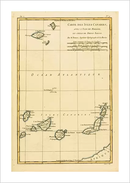
Fine Art Print : Map Of The Canary Isles, Madeira And Porto Santo, Circa. 1760. From "Atlas De Toutes Les Parties Connues Du Globe Terrestre "By Cartographer Rigobert Bonne. Published Geneva Circa. 1760

![]()
Fine Art Prints from Design Pics
Map Of The Canary Isles, Madeira And Porto Santo, Circa. 1760. From "Atlas De Toutes Les Parties Connues Du Globe Terrestre "By Cartographer Rigobert Bonne. Published Geneva Circa. 1760
Map Of The Canary Isles, Madeira And Porto Santo, Circa.1760. From " Atlas De Toutes Les Parties Connues Du Globe Terrestre " By Cartographer Rigobert Bonne. Published Geneva Circa. 1760
Design Pics offers Distinctively Different Imagery representing over 1,500 contributors
Media ID 18186471
© Ken Welsh / Design Pics
Cartography Geography Isles Mapmaking Plate Porto Santo Canary Madeira
21"x14" (+3" Border) Fine Art Print
Step back in time with our exquisite Fine Art Print of the Map of the Canary Isles, Madeira, and Porto Santo, circa 1760. This stunning vintage map is taken from the "Atlas De Toutes Les Parties Connues Du Globe Terrestre" by renowned cartographer Rigobert Bonne. Published in Geneva around 1760, this map offers a captivating glimpse into the historical cartography of the Canary Islands, Madeira, and Porto Santo. With intricate detail and beautiful antique aesthetics, this Fine Art Print is a must-have for history enthusiasts, collectors, and those who appreciate the art of cartography. Bring a piece of the past into your home or office with this beautiful, vintage map from Media Storehouse.
21x14 image printed on 27x20 Fine Art Rag Paper with 3" (76mm) white border. Our Fine Art Prints are printed on 300gsm 100% acid free, PH neutral paper with archival properties. This printing method is used by museums and art collections to exhibit photographs and art reproductions.
Our fine art prints are high-quality prints made using a paper called Photo Rag. This 100% cotton rag fibre paper is known for its exceptional image sharpness, rich colors, and high level of detail, making it a popular choice for professional photographers and artists. Photo rag paper is our clear recommendation for a fine art paper print. If you can afford to spend more on a higher quality paper, then Photo Rag is our clear recommendation for a fine art paper print.
Estimated Image Size (if not cropped) is 35.5cm x 53.3cm (14" x 21")
Estimated Product Size is 50.8cm x 68.6cm (20" x 27")
These are individually made so all sizes are approximate
Artwork printed orientated as per the preview above, with portrait (vertical) orientation to match the source image.
FEATURES IN THESE COLLECTIONS
> Maps and Charts
> Related Images
EDITORS COMMENTS
This print showcases a stunning map from the 18th century, titled "Map Of The Canary Isles, Madeira And Porto Santo, Circa. 1760". Created by renowned cartographer Rigobert Bonne and published in Geneva around the same time, this piece is a true testament to the artistry and precision of historical mapmaking. The vibrant colors and intricate details of this engraving bring to life the beauty and complexity of these islands. From the volcanic landscapes of Tenerife to the lush forests of Madeira, each region is meticulously depicted with accuracy and elegance. As we gaze upon this vertical plate illustration, we are transported back in time to an era when exploration was at its peak. This map not only serves as a geographical reference but also offers us a glimpse into the world as it was perceived centuries ago. Ken Welsh's expert photography captures every nuance of this remarkable print, allowing us to appreciate its historical significance while marveling at its visual appeal. Whether you're an avid collector or simply intrigued by cartography and geography, this print is sure to captivate your imagination. Displaying "Map Of The Canary Isles, Madeira And Porto Santo" in your home or office will undoubtedly spark conversations about history, culture, and our ever-evolving understanding of our planet's vast landscapes.
MADE IN THE USA
Safe Shipping with 30 Day Money Back Guarantee
FREE PERSONALISATION*
We are proud to offer a range of customisation features including Personalised Captions, Color Filters and Picture Zoom Tools
SECURE PAYMENTS
We happily accept a wide range of payment options so you can pay for the things you need in the way that is most convenient for you
* Options may vary by product and licensing agreement. Zoomed Pictures can be adjusted in the Cart.


