Home > Africa > Cape Verde > Maps
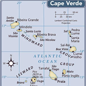
Map of Cape Verde Islands, c.1900 (engraving)
")
![]()
Wall Art and Photo Gifts from Fine Art Finder
Map of Cape Verde Islands, c.1900 (engraving)
533379 Map of Cape Verde Islands, c.1900 (engraving); (add.info.: Map of Cape Verde Islands, circa 1902, from the 10th edition of Encyclopaedia Britannica.); Encyclopaedia Britannica/UIG
Media ID 38105138
© Encyclopaedia Britannica/UIG / Bridgeman Images
1902 19th Century Style Archipelago Atlantic Ocean Guidance Illustration Technique Meridian Navigational Equipment Number Old Fashioned Physical Geography Portugal The Past Western Script
FEATURES IN THESE COLLECTIONS
> Africa
> Cape Verde
> Maps
> Africa
> Cape Verde
> Related Images
> Europe
> Portugal
> Paintings
> Europe
> Portugal
> Related Images
> Fine Art Finder
> Temp Classification
EDITORS COMMENTS
This engraving from the 10th edition of Encyclopaedia Britannica showcases a Map of Cape Verde Islands, circa 1900. The intricate details and craftsmanship of this map transport us back to a time of exploration and discovery in the 19th century.
The archipelago of Cape Verde Islands is beautifully depicted with Western script labeling each island, providing navigational guidance for sailors and explorers. This historical piece reflects the physical geography of the islands in the Atlantic Ocean, highlighting their importance as a strategic location for Portugal during this era.
The old-fashioned style of cartography seen in this print evokes a sense of nostalgia for a bygone era when maps were essential tools for navigation at sea. The meridians and numbers on the map add to its authenticity and historical significance.
As we gaze upon this illustration, we are reminded of the rich history and cultural heritage embedded within these islands. The absence of people in the image allows us to focus solely on the beauty and complexity of this detailed map, transporting us back in time to an age of exploration and adventure.
Overall, this Map of Cape Verde Islands serves as a timeless reminder of our past while also showcasing the artistry and precision that went into creating such important navigational tools.
MADE IN THE USA
Safe Shipping with 30 Day Money Back Guarantee
FREE PERSONALISATION*
We are proud to offer a range of customisation features including Personalised Captions, Color Filters and Picture Zoom Tools
SECURE PAYMENTS
We happily accept a wide range of payment options so you can pay for the things you need in the way that is most convenient for you
* Options may vary by product and licensing agreement. Zoomed Pictures can be adjusted in the Cart.