Home > Animals > Mammals > Cercopithecidae > Margarita
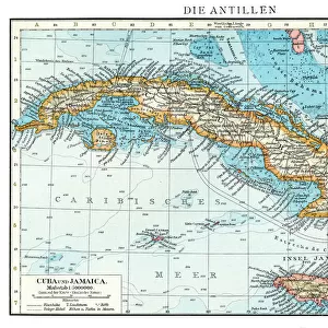
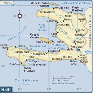
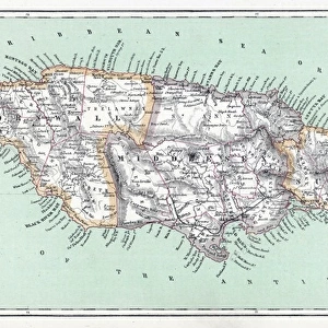
Geography: map of the island of Cuba, the island of Hispaniola (Santo Domingo and Haiti), the island of Jamaica, the island of Margarita (Margarita) and the island of Saint John. Plate taken from an atlas of 1602. Biblioteca Jose Marti, Havana, Cuba
, the island of Jamaica, the island of Margarita (Margarita) and the island of Saint John. Plate taken from an atlas of 1602. Biblioteca Jose Marti, Havana, Cuba")
![]()
Wall Art and Photo Gifts from Fine Art Finder
Geography: map of the island of Cuba, the island of Hispaniola (Santo Domingo and Haiti), the island of Jamaica, the island of Margarita (Margarita) and the island of Saint John. Plate taken from an atlas of 1602. Biblioteca Jose Marti, Havana, Cuba
VEN5031283 Geography: map of the island of Cuba, the island of Hispaniola (Santo Domingo and Haiti), the island of Jamaica, the island of Margarita (Margarita) and the island of Saint John. Plate taken from an atlas of 1602. Biblioteca Jose Marti, Havana, Cuba; (add.info.: Geography: map of the island of Cuba, the island of Hispaniola (Santo Domingo and Haiti), the island of Jamaica, the island of Margarita (Margarita) and the island of Saint John. Plate taken from an atlas of 1602. Biblioteca Jose Marti, Havana, Cuba); © Marage Photos
Media ID 38164362
© © Marage Photos / Bridgeman Images
17eme Siecle 17th Centuries Amerique (continent) Amerique Centrale Amerique Du Nord Carte Geographique Central America Cuba Cuba Cubain Cubaine Cubains Cubaines Cuban Dominium Etats Unis Geographical Map Geographie Haiti Jamaica Jamaican Saint Domingue Stockravenna
FEATURES IN THESE COLLECTIONS
> Animals
> Mammals
> Cercopithecidae
> Margarita
> Maps and Charts
> Early Maps
> North America
> Cuba
> Cuba Heritage Sites
> Old Havana and its Fortification System
> North America
> Cuba
> Havana
> North America
> Cuba
> Maps
> North America
> Cuba
> Related Images
> North America
> Haiti
> Maps
> North America
> Haiti
> Related Images
> North America
> Jamaica
> Maps
EDITORS COMMENTS
This stunning print captures a piece of history from the 17th century, showcasing a detailed map of several Caribbean islands. The map includes the island of Cuba, Hispaniola (which is now divided into Santo Domingo and Haiti), Jamaica, Margarita Island, and Saint John. Each island is intricately depicted with geographical features and place names, giving us a glimpse into what these tropical paradises looked like centuries ago.
Taken from an atlas dating back to 1602, this plate is housed in the Biblioteca Jose Marti in Havana, Cuba. The fine engraving work on the map reflects the craftsmanship and attention to detail that was characteristic of cartography during this time period.
As we study this historical map, we can imagine sailors using it to navigate through the Caribbean waters or explorers planning their next voyage to these exotic destinations. It serves as a reminder of how maps have played a crucial role in shaping our understanding of geography and connecting different parts of the world.
With its rich colors and intricate design, this print not only showcases a beautiful piece of art but also invites us to explore the history and culture of these enchanting islands in the Caribbean Sea.
MADE IN THE USA
Safe Shipping with 30 Day Money Back Guarantee
FREE PERSONALISATION*
We are proud to offer a range of customisation features including Personalised Captions, Color Filters and Picture Zoom Tools
SECURE PAYMENTS
We happily accept a wide range of payment options so you can pay for the things you need in the way that is most convenient for you
* Options may vary by product and licensing agreement. Zoomed Pictures can be adjusted in the Cart.