Home > Europe > France > Paris > Maps
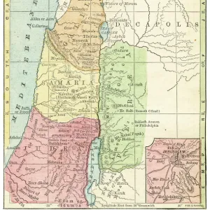
Map of Palestine - in "Palestina"by Hadriani Relandi, 1714

![]()
Wall Art and Photo Gifts from Fine Art Finder
Map of Palestine - in "Palestina"by Hadriani Relandi, 1714
LSE4108789 Map of Palestine - in " Palestina" by Hadriani Relandi, 1714. by Unknown artist, (18th century); Bibliotheque des Franciscains, Paris, France; (add.info.: Map of Palestine - in " Palestina" by Hadriani Relandi, 1714.); Photo eLeonard de Selva; out of copyright
Media ID 23698058
© Leonard de Selva / Bridgeman Images
Comppas Earth Globe Geographical Map Palestine Palestinian Arab Civilization
FEATURES IN THESE COLLECTIONS
> Arts
> Artists
> Related Images
> Asia
> Palestine
> Related Images
> Europe
> France
> Paris
> Maps
> Europe
> France
> Paris
> Related Images
> Fine Art Finder
> Artists
> Unknown Artist
> Maps and Charts
> Related Images
EDITORS COMMENTS
This print showcases a historical treasure, the "Map of Palestine - in 'Palestina' by Hadriani Relandi, 1714". Created by an unknown artist in the 18th century, this map is housed in the Bibliotheque des Franciscains in Paris, France. The image captures the intricate details and artistry of this significant geographical map. Intriguingly adorned with angels and a woman holding an earth globe, this map represents not only the physical landscape but also reflects the cultural significance of Arab civilization. The presence of an angel and compass adds a touch of mystique to its overall composition. The Map of Palestine holds immense historical value as it provides insights into how people perceived and understood geography during that time period. It serves as a window into past civilizations and their understanding of land boundaries. Photographed by Leonard de Selva, this stunning print allows us to appreciate both the artistic beauty and scholarly importance embedded within this ancient cartographic masterpiece. As we gaze upon it, we are transported back to a different era when exploration and discovery were at their peak. This photograph is not just about commercial use; rather, it invites us to delve deeper into history's rich tapestry while marveling at human ingenuity through centuries-old maps like these.
MADE IN THE USA
Safe Shipping with 30 Day Money Back Guarantee
FREE PERSONALISATION*
We are proud to offer a range of customisation features including Personalised Captions, Color Filters and Picture Zoom Tools
SECURE PAYMENTS
We happily accept a wide range of payment options so you can pay for the things you need in the way that is most convenient for you
* Options may vary by product and licensing agreement. Zoomed Pictures can be adjusted in the Cart.