Home > Asia > Afghanistan > Maps
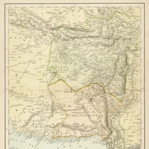
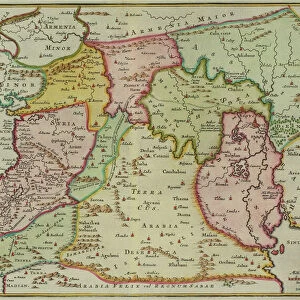
Map of Asia, including Armenia, Iran, Afghanistan, with wind rose, details of ports

![]()
Wall Art and Photo Gifts from Fine Art Finder
Map of Asia, including Armenia, Iran, Afghanistan, with wind rose, details of ports
AIS5334412 Map of Asia, including Armenia, Iran, Afghanistan, with wind rose, details of ports, coasts and sea routes, in Atlas de Joan Martines, 1587 (colour manuscript) by Martines, Joan (1556-1590); Biblioteca Nacional, Madrid, Spain; (add.info.: Map of Asia, including Armenia, Iran, Afghanistan, with wind rose, details of ports, coasts and sea routes. Manuscript in colour, in atlas portulan, made in Messina (Italy) in 1587. Martines, Joan (1556-1590) National Library of Madrid (Spain).); eIberfoto; Spanish, out of copyright
Media ID 23340904
© Iberfoto / Bridgeman Images
Afghanistan Armenia Atlas Book Of Maps Cartography Central Asia Geographical Map Iran Iranian Iranians Cinquecento Medieval Period
FEATURES IN THESE COLLECTIONS
> Asia
> Afghanistan
> Maps
> Asia
> Afghanistan
> Related Images
> Asia
> Armenia
> Related Images
> Asia
> Iran
> Related Images
> Europe
> Armenia
> Related Images
> Fine Art Finder
> Artists
> Joan Martines
> Fine Art Finder
> Artists
> Spanish School (after)
EDITORS COMMENTS
This vibrant and intricate print captures a 16th-century map of Asia, showcasing the diverse regions including Armenia, Iran, and Afghanistan. Created by Joan Martines in 1587, this color manuscript is housed in the National Library of Madrid, Spain. The map not only provides geographical details but also features a wind rose that indicates directions and sea routes. With meticulous attention to detail, it highlights ports along the coasts of these Asian countries. This atlas portulan was crafted in Messina, Italy during the Cinquecento period. As we delve into this historical artifact, we are transported back to an era when cartography played a crucial role in understanding our world. The artistry displayed within this manuscript reflects both the skill of its creator and the importance placed on accurate representation during medieval times. From bustling trade routes to ancient civilizations dotting Central Asia's landscapes, this map offers a glimpse into the rich history and cultural heritage of these nations. It serves as a testament to human curiosity and exploration that has shaped our understanding of geography over centuries. With its vivid colors and intricate details, this print invites us to appreciate not only its artistic value but also its significance as an invaluable piece of historical documentation.
MADE IN THE USA
Safe Shipping with 30 Day Money Back Guarantee
FREE PERSONALISATION*
We are proud to offer a range of customisation features including Personalised Captions, Color Filters and Picture Zoom Tools
SECURE PAYMENTS
We happily accept a wide range of payment options so you can pay for the things you need in the way that is most convenient for you
* Options may vary by product and licensing agreement. Zoomed Pictures can be adjusted in the Cart.