Fraud Blocker Skip to main content

Home > Arts > Artists > B > Babylonian Babylonian

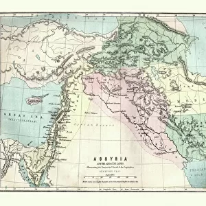
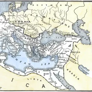
Map of Assyria, Chaldea and Adjacent Countries, 1890. Creator: Unknown

Map of Assyria, Chaldea and Adjacent Countries, 1890. Creator: Unknown
In Stock
We accept all major credit cards
Framed Photos
Buy from $79.99
Photo Prints
Buy from $9.99
Jigsaw Puzzles
Buy from $39.99
Poster Prints
Buy from $24.99
Canvas Prints
Buy from $99.99
Fine Art Prints
Buy from $60.90
Metal Prints
Buy from $169.99
Home Decor
Buy from $16.99

Heritage Images Photo Prints and Wall Art

Map of Assyria, Chaldea and Adjacent Countries, 1890. Creator: Unknown

Map of Assyria, Chaldea and Adjacent Countries, 1890. Assyria was a Mesopotamian kingdom from 25th century BC to 612 BC- 609 BC. Chaldea was a country between the late 10th or early 9th and mid-6th centuries BC, after which it was absorbed and assimilated into Babylonia. From " Cassells Illustrated Universal History, Vol. I - Early and Greek History", by Edmund Ollier. [Cassell and Company, Limited, London, Paris and Melbourne, 1890]. Heritage Images features heritage image collections. © The Print Collector/Heritage Images

Media ID 19065557

6th Century Bc 7th Century Bc 8th Century Bc Aged Assyria Babylonia Babylonian Border Cassell And Cassell And Co Cassell And Company Cassells Cassells Illustrated Universal History Early And Greek History Edmund Edmund Ollier Kingdom Mesopotamia Mesopotamian Mesopotamien Ollier Cassell And Company Ltd Chaldea

FEATURES IN THESE COLLECTIONS

> Arts > Artists > B > Babylonian Babylonian

> Arts > Literature > Illustration

> Arts > Literature

> Arts > Minimalist artwork > Monochrome artwork > Fine art

> Arts > Minimalist artwork > Monochrome artwork > Monochrome paintings

> Europe > France > Paris > Maps

> Europe > Greece > Maps

> Europe > Greece > Posters

> Europe > Greece > Related Images

> Historic > Ancient civilizations > Ancient Greece > Greek history

SECURE PAYMENTS
We happily accept a wide range of payment options so you can pay for the things you need in the way that is most convenient for you

MADE IN THE USA
Safe Shipping with 30 Day Money Back Guarantee

FREE PERSONALISATION
We are proud to offer a range of customisation including Cropping, Captions, and Filters. Zoom Cropping can be adjusted in the Basket.


EDITORS COMMENTS

This print showcases a historical treasure, the "Map of Assyria, Chaldea and Adjacent Countries" from 1890. Created by an unknown artist, this map provides a glimpse into the ancient kingdoms that once thrived in Mesopotamia. Assyria, a powerful kingdom that spanned from the 25th century BC to 612 BC-609 BC, is depicted with intricate detail on this aged engraving. Its borders are clearly outlined alongside neighboring regions such as Chaldea. Chaldea itself existed between the late 10th or early 9th centuries BC until its assimilation into Babylonia during the mid-6th century BC. Taken from "Cassells Illustrated Universal History". Volume I - Early and Greek History by Edmund Ollier, this monochrome illustration transports us back to a time when these ancient civilizations flourished. The fine lines and delicate shading evoke a sense of reverence for their rich history. As we gaze upon this antique map, we are reminded of the significant role Mesopotamia played in shaping human civilization. It serves as both an educational tool and a work of art; its presence on our walls invites contemplation about our shared past. The print collector who discovered this gem has preserved not only an important piece of geography but also literature and culture from centuries ago. This remarkable find offers us insight into forgotten worlds while reminding us of humanity's enduring fascination with exploration and discovery.


Framed Prints

Step back in time with our exquisite Framed Print of the Map of Assyria, Chaldea, and Adjacent Countries from 1890. This rare and intriguing piece, sourced from Heritage Images, showcases the ancient territories of Assyria and Chaldea during their historical reign. The map, created in the late 19th century, offers a fascinating glimpse into the rich history and geography of this ancient civilization. Add this captivating and conversation-starting piece to your home or office decor, and let the stories of Assyria and Chaldea come alive.


Photo Prints

Step back in time with our vintage Map of Assyria, Chaldea, and Adjacent Countries from Heritage Images, dated 1890. This captivating antique map offers a glimpse into ancient history, showcasing the territories of Assyria, an influential Mesopotamian kingdom from 2500 BC to 612 BC-609 BC, and its neighboring regions. Add an air of historical intrigue to your home or office with this beautifully detailed and intricately designed print, perfect for history enthusiasts, educators, or anyone with an appreciation for the past. Order now and bring a piece of the past into your present.


Poster Prints

Step back in time with our vintage Map of Assyria, Chaldea, and Adjacent Countries from 1890. This intriguing poster print, sourced from Heritage Images, showcases the ancient territories of Assyria and Chaldea, once powerful Mesopotamian kingdoms that existed from the 25th century BC to 612 BC-609 BC. Add an air of history and mystery to your space with this beautifully preserved piece of cartographic history. Unknown creator, but the detail and accuracy of the map are a testament to the craftsmanship of the time. A must-have for history buffs, educators, or anyone with a passion for the ancient world.


Jigsaw Puzzles

Discover the rich history of ancient civilizations with our captivating jigsaw puzzle from Media Storehouse. This intricately detailed puzzle features a vintage map of Assyria, Chaldea, and adjacent countries from 1890. Explore the lands of Assyria, an influential Mesopotamian kingdom from the 25th century BC to 612 BC-609 BC, and its neighboring territories as depicted in this beautifully preserved antique map. Ideal for history enthusiasts, puzzle collectors, or anyone seeking a challenging and educational pastime, this puzzle offers a unique and engaging way to delve into the past. Unravel the puzzle pieces and uncover the history hidden within.

diamond
Made With High Grade Materials
thumb_up
Professional Quality Finish
package_2
Carefully Packed To Aid Safe Arrival

You May Also Like


Map of Assyria illustrating the biblical Patriarchal AgeMap of Assyria illustrating the biblical Patriarchal Age
Add to Basket
Present Trouble, 1964. Artist: Michael WaltersPresent Trouble, 1964. Artist: Michael Walters
Add to Basket
MotoGPMotoGP
Add to Basket
Lady Mary Brandon, Baroness Monteagle, 1510 - c. 1544. 1812 (engraving)Lady Mary Brandon, Baroness Monteagle, 1510 - c. 1544. 1812 (engraving)
Add to Basket
Farm still lifeFarm still life
Add to Basket
Map of Asia, including Armenia, Iran, Afghanistan, with wind rose, details of portsMap of Asia, including Armenia, Iran, Afghanistan, with wind rose, details of ports
Add to Basket
Lady with lanternsLady with lanterns
Add to Basket
Auto-Union at a pitstop on Avus track, Berlin, GermanyAuto-Union at a pitstop on Avus track, Berlin, Germany
Add to Basket
The Temple of the Sun in Nineveh (engraving)The Temple of the Sun in Nineveh (engraving)
Add to Basket
Pre-Persian, circa 600 B. C. c1915. Creator: Emery Walker LtdPre-Persian, circa 600 B. C. c1915. Creator: Emery Walker Ltd
Add to Basket
Rome v. Parthia, circa 50 B. C. c1915. Creator: Emery Walker LtdRome v. Parthia, circa 50 B. C. c1915. Creator: Emery Walker Ltd
Add to Basket
Small mountain lake, Parc Natural de la Vall de Sorteny, AndorraSmall mountain lake, Parc Natural de la Vall de Sorteny, Andorra
Add to Basket

Gallery Wall Inspiration

Babylons lion. Lion decorated the Processional Wal (Ishtar
Mesopotamia, Ur, ziggurat
Lion, Babylon
Babylonian wall tiles
3000 BC Cuneiform writing on clay slab, front view
Babylonian wall tiles
The Landing Stage at Ahvaz, Iran - WWI Xmas card
Cylinder of Cyrus the Great with text written in akkadian cu
Illustrated map of Indus Valley civilisation
Mesopotamia. Clay Tablet. Pictographs drawn. Iraq. Late Preh
Neo-Sumerian. Statue of Gudea. Girsu, Iraq. 2120 BC. Cuneifo
Antique map of the Middle East by Halma
Illustration of strip of land known as the fertile crescent which stretched from Egypt through Canaan and Mesopotamia to Babylonia in the Old Testament
Illustration of ancient city of Babylon
Foundation figure of king Shulgi of Ur, carrying a basket, c. 2094-2047 BC (copper)
Openwork plaque with a striding sphinx, c. 9th-8th century B. C. (ivory)
View of the mounds of Kouyunjik [Quyunjik] and Nebbi Yunus
Mesopotamia: low relief in limestone of Ur-Nanshe (Our nanshe), King of Lagash
Illustration of map highlighting Indus Valley region and ancient tablet showing water buffalo
Map of Assyria, Chaldea and Adjacent Countries, 1890. Creator: Unknown
Bronze axe head from Mesopotamia
Statue of a female in worshipping pose, Khafajah, Mesopotamia, c.2650-2550 BC (gypsum)
Asia Minor, Armenia, Mesopotamia, Assyria and Syria in Antiquite (Mesopotamian nations in the ancient times) Engraving from " Atlas Universel" by Houze, 1851
The Ishtar Gate, Babylonian, c.580 BC (photo)
Mesopotamian art: Naked woman. Terracotta, 2nd millennium BC (around 2000 BC)
Figurine of a nude woman, Mesopotamia, c. 2000-1800 BC (clay)
Fragments of mural paintings, palace of Tukulti-Ninurta I, Kar-Tukulti-Ninurta, Assyria, (1928)

Discover Our Collections


LiteratureLiterature
View Collection
IllustrationIllustration
View Collection
Greece Related ImagesGreece Related Images
View Collection
MapsMaps
View Collection
Babylonian BabylonianBabylonian Babylonian
View Collection
MapsMaps
View Collection
PostersPosters
View Collection
Greek historyGreek history
View Collection
Fine artFine art
View Collection
Monochrome paintingsMonochrome paintings
View Collection


© Copyright Media Storehouse, All Rights Reserved 2003 - 2024
Facebook     Pinterest     Card Payments     Reviews IO