Home > Maps and Charts > Related Images
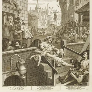
Map showing location of Lilliput from first edition of

![]()
Wall Art and Photo Gifts from Fine Art Finder
Map showing location of Lilliput from first edition of
3514775 Map showing location of Lilliput from first edition of Travels into Several Remote Nations of the World better know as Gullivers Travels by Jonathan Swift by English School, (18th century); Private Collection; (add.info.: Map showing location of Lilliput from first edition of Travels into Several Remote Nations of the World better know as Gullivers Travels by Jonathan Swift (1667-1745).); Photo eAF Fotografie; English, out of copyright
Media ID 22729824
© AF Fotografie / Bridgeman Images
1699 1700s 1726 Edition Gulliver Gullivers Islands Jonathan Lilliput Menippean Parody Sumatra Swift Travels Voyage
FEATURES IN THESE COLLECTIONS
> Fine Art Finder
> Artists
> English School
> Fine Art Finder
> Artists
> Paul Gavarni
> Maps and Charts
> Related Images
> Maps and Charts
> World
EDITORS COMMENTS
This print showcases a historical map that reveals the intriguing location of Lilliput, a fictional island from the first edition of Jonathan Swift's renowned masterpiece, "Travels into Several Remote Nations of the World" better known as Gulliver's Travels. Crafted by an English School artist in the 18th century and now part of a private collection, this map offers a fascinating glimpse into Swift's imaginative world. The map depicts Lilliput nestled among other islands in what appears to be Sumatra, highlighting Swift's satirical commentary on European politics and society during the 1700s. With its clever parody and sharp wit, Gulliver's Travels has become an enduring classic that continues to captivate readers worldwide. As we delve into this visual treasure trove, we are transported back in time to witness Gulliver's extraordinary voyage through various remote nations. The intricate details on this map not only serve as a geographical guide but also offer insight into Swift's menippean satire. From Blefuscu to Sillabar, each place name carries symbolic significance within the narrative. With its rich history and cultural significance, this print is more than just an artistic representation; it serves as a gateway for exploration and imagination. Whether you are an avid reader or simply fascinated by cartography and travel literature from centuries past, this piece invites you to embark on your own literary adventure through Lilliput alongside Jonathan Swift himself.
MADE IN THE USA
Safe Shipping with 30 Day Money Back Guarantee
FREE PERSONALISATION*
We are proud to offer a range of customisation features including Personalised Captions, Color Filters and Picture Zoom Tools
SECURE PAYMENTS
We happily accept a wide range of payment options so you can pay for the things you need in the way that is most convenient for you
* Options may vary by product and licensing agreement. Zoomed Pictures can be adjusted in the Cart.