Home > Arts > Artists > P > Francis Place
A general chart of the northern navigation, 1675 (coloured engraving)
")
![]()
Wall Art and Photo Gifts from Fine Art Finder
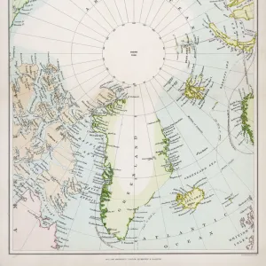
A general chart of the northern navigation, 1675 (coloured engraving)
7340043 A general chart of the northern navigation, 1675 (coloured engraving) by Seller, John (1632-97); 43.5x54 cm; National Maritime Museum, London, UK; (add.info.: Creator: John Seller; Francis Lamb; John Darby
Scale: [ca. 1:9 000 000 (bar)]. Cartographic Note: Borders graduated for latitude. Bar scales in English and French leagues, Spanish leagues and Dutch miles. Additional Places: Northern Europe, Iceland, Greenland, Novaya Zemlya. Contents Note: There is a continuation of Nova Zemla inset at the same scale at the top right. There are two other insets at different, unstated, scales, separated by decorative tendrils: The River Dvina in Russia going up to Archangel [N at 226 degrees]; and The Sound [N at 272 degrees].); © National Maritime Museum, Greenwich, London
Media ID 38372182
© © National Maritime Museum, Greenwich, London / Bridgeman Images
Danish Denmark Greenland Iceland Icelander Icelandic Norway Norway Norwegian Norwegian Norwegians Sverige Sweden
FEATURES IN THESE COLLECTIONS
> Arts
> Artists
> P
> Francis Place
> Arts
> Artists
> S
> John Seller
> Europe
> Denmark
> Related Images
> Europe
> Iceland
> Related Images
> Fine Art Finder
> Artists
> John Diston
> Fine Art Finder
> Artists
> John Seller
EDITORS COMMENTS
This stunning colored engraving from 1675, titled "A General Chart of the Northern Navigation," offers a fascinating glimpse into the world of cartography in the 17th century. Created by John Seller, Francis Lamb, and John Darby, this intricate map showcases various regions in Northern Europe including Iceland, Greenland, and Novaya Zemlya.
The borders of the map are graduated for latitude, with bar scales provided in English and French leagues as well as Spanish leagues and Dutch miles. Insets depicting The River Dvina in Russia leading up to Archangel and The Sound add further detail to this comprehensive navigation chart.
With its detailed illustrations and meticulous attention to geographical accuracy, this print is not only a valuable historical artifact but also a work of art in its own right. The vibrant colors used in the engraving bring each region to life, inviting viewers to explore the wonders of Northern Europe through the eyes of 17th-century cartographers.
Displayed at the National Maritime Museum in London, UK, this print serves as a reminder of our enduring fascination with maps and exploration throughout history. It stands as a testament to human curiosity and ingenuity when it comes to navigating unknown territories and uncovering new discoveries.
MADE IN THE USA
Safe Shipping with 30 Day Money Back Guarantee
FREE PERSONALISATION*
We are proud to offer a range of customisation features including Personalised Captions, Color Filters and Picture Zoom Tools
SECURE PAYMENTS
We happily accept a wide range of payment options so you can pay for the things you need in the way that is most convenient for you
* Options may vary by product and licensing agreement. Zoomed Pictures can be adjusted in the Cart.